You are here: Home > Network List > CI - Caltech Regional Seismic Network Stations List
> Station MPP McPhearson Peak > Earthquake Result Viewer
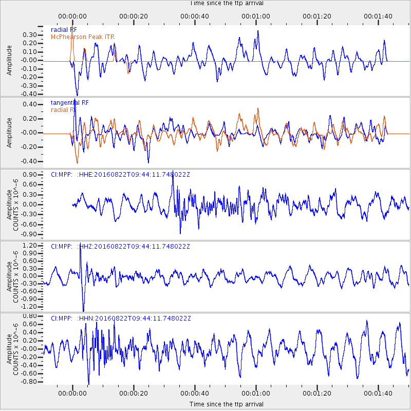
MPP McPhearson Peak - Earthquake Result Viewer
*The percent match for this event was below the threshold and hence no stack was calculated.
| Earthquake location: |
Southeast Of Honshu, Japan |
| Earthquake latitude/longitude: |
29.9/139.1 |
| Earthquake time(UTC): |
2016/08/22 (235) 09:33:08 GMT |
| Earthquake Depth: |
404 km |
| Earthquake Magnitude: |
5.6 MB |
| Earthquake Catalog/Contributor: |
NEIC PDE/NEIC COMCAT |
|
| Network: |
CI Caltech Regional Seismic Network |
| Station: |
MPP McPhearson Peak |
| Lat/Lon: |
34.89 N/119.81 W |
| Elevation: |
1739 m |
|
| Distance: |
81.6 deg |
| Az: |
54.635 deg |
| Baz: |
300.524 deg |
| Ray Param: |
$rayparam |
*The percent match for this event was below the threshold and hence was not used in the summary stack. |
|
| Radial Match: |
58.39753 % |
| Radial Bump: |
400 |
| Transverse Match: |
58.425125 % |
| Transverse Bump: |
400 |
| SOD ConfigId: |
11737051 |
| Insert Time: |
2019-04-25 08:01:27.225 +0000 |
| GWidth: |
2.5 |
| Max Bumps: |
400 |
| Tol: |
0.001 |
|
Signal To Noise
| Channel | StoN | STA | LTA |
| CI:MPP: :HHZ:20160822T09:44:11.748022Z | 2.8240795 | 5.3747567E-7 | 1.9031889E-7 |
| CI:MPP: :HHN:20160822T09:44:11.748022Z | 1.3953725 | 2.5615995E-7 | 1.8357818E-7 |
| CI:MPP: :HHE:20160822T09:44:11.748022Z | 1.8358536 | 3.524114E-7 | 1.9196051E-7 |
| Arrivals |
| Ps | |
| PpPs | |
| PsPs/PpSs | |


