You are here: Home > Network List > CN - Canadian National Seismograph Network Stations List
> Station INK INUVIK, NT > Earthquake Result Viewer
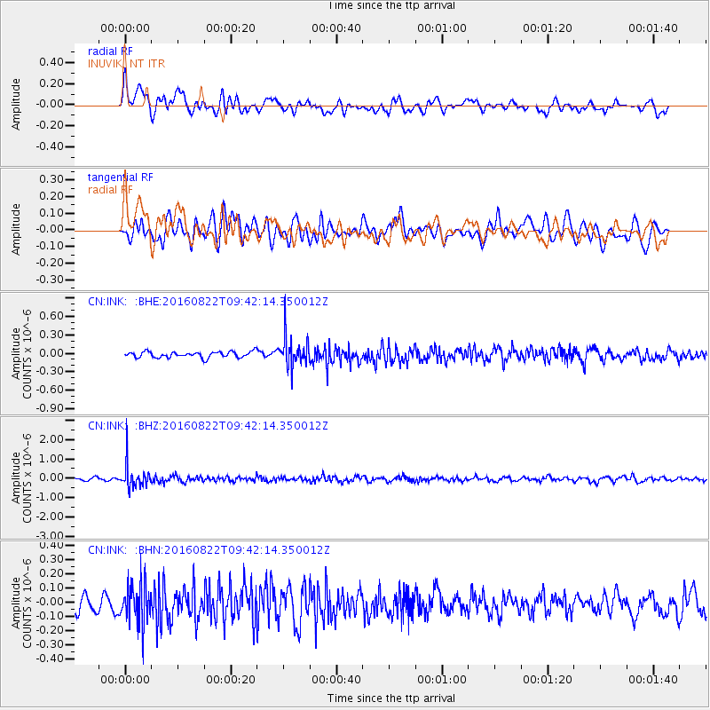
INK INUVIK, NT - Earthquake Result Viewer
*The percent match for this event was below the threshold and hence no stack was calculated.
| Earthquake location: |
Southeast Of Honshu, Japan |
| Earthquake latitude/longitude: |
29.9/139.1 |
| Earthquake time(UTC): |
2016/08/22 (235) 09:33:08 GMT |
| Earthquake Depth: |
404 km |
| Earthquake Magnitude: |
5.6 MB |
| Earthquake Catalog/Contributor: |
NEIC PDE/NEIC COMCAT |
|
| Network: |
CN Canadian National Seismograph Network |
| Station: |
INK INUVIK, NT |
| Lat/Lon: |
68.31 N/133.53 W |
| Elevation: |
44 m |
|
| Distance: |
61.6 deg |
| Az: |
24.969 deg |
| Baz: |
279.619 deg |
| Ray Param: |
$rayparam |
*The percent match for this event was below the threshold and hence was not used in the summary stack. |
|
| Radial Match: |
55.698807 % |
| Radial Bump: |
400 |
| Transverse Match: |
54.15574 % |
| Transverse Bump: |
400 |
| SOD ConfigId: |
11737051 |
| Insert Time: |
2019-04-25 08:02:00.883 +0000 |
| GWidth: |
2.5 |
| Max Bumps: |
400 |
| Tol: |
0.001 |
|
Signal To Noise
| Channel | StoN | STA | LTA |
| CN:INK: :BHZ:20160822T09:42:14.350012Z | 10.218109 | 6.122203E-7 | 5.991522E-8 |
| CN:INK: :BHN:20160822T09:42:14.350012Z | 2.5612793 | 1.436217E-7 | 5.6074207E-8 |
| CN:INK: :BHE:20160822T09:42:14.350012Z | 4.8481092 | 2.333739E-7 | 4.8137096E-8 |
| Arrivals |
| Ps | |
| PpPs | |
| PsPs/PpSs | |


