You are here: Home > Network List > IC - New China Digital Seismograph Network Stations List
> Station WMQ Urumqi, Xinjiang Province, China > Earthquake Result Viewer
WMQ Urumqi, Xinjiang Province, China - Earthquake Result Viewer
| Earthquake location: |
Southeast Of Honshu, Japan |
| Earthquake latitude/longitude: |
29.9/139.1 |
| Earthquake time(UTC): |
2016/08/22 (235) 09:33:08 GMT |
| Earthquake Depth: |
404 km |
| Earthquake Magnitude: |
5.6 MB |
| Earthquake Catalog/Contributor: |
NEIC PDE/NEIC COMCAT |
|
| Network: |
IC New China Digital Seismograph Network |
| Station: |
WMQ Urumqi, Xinjiang Province, China |
| Lat/Lon: |
43.81 N/87.70 E |
| Elevation: |
850 m |
|
| Distance: |
42.8 deg |
| Az: |
303.545 deg |
| Baz: |
91.227 deg |
| Ray Param: |
0.0711614 |
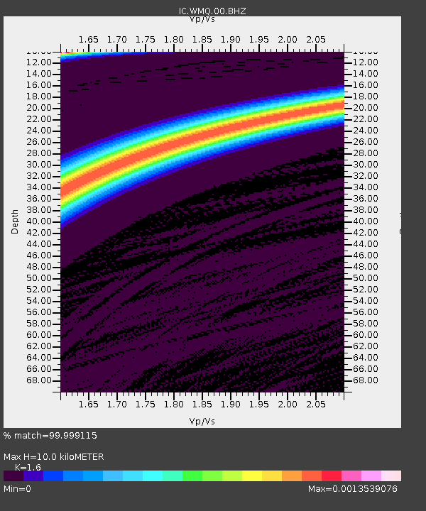
| Estimated Moho Depth: |
10.0 km |
| Estimated Crust Vp/Vs: |
1.60 |
| Assumed Crust Vp: |
6.242 km/s |
| Estimated Crust Vs: |
3.901 km/s |
| Estimated Crust Poisson's Ratio: |
0.18 |
|
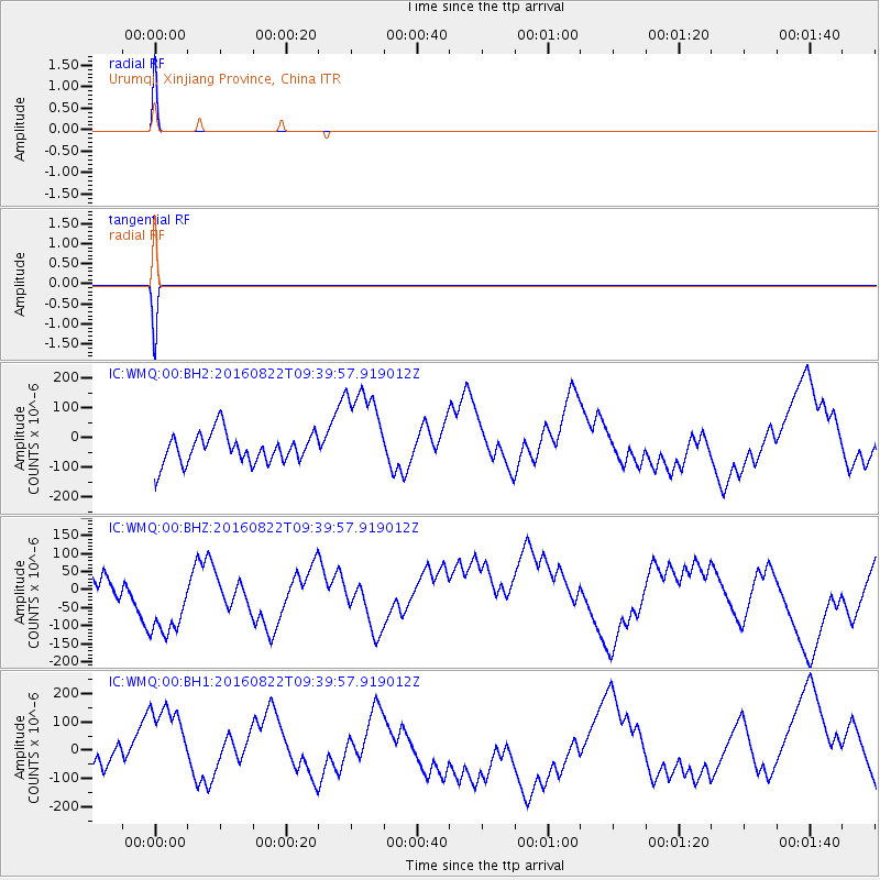
| Radial Match: |
99.999115 % |
| Radial Bump: |
2 |
| Transverse Match: |
99.99881 % |
| Transverse Bump: |
2 |
| SOD ConfigId: |
11737051 |
| Insert Time: |
2019-04-25 08:03:12.544 +0000 |
| GWidth: |
2.5 |
| Max Bumps: |
400 |
| Tol: |
0.001 |
|
Signal To Noise
| Channel | StoN | STA | LTA |
| IC:WMQ:00:BHZ:20160822T09:39:57.919012Z | 3.2299528 | 1.2438123E-4 | 3.8508682E-5 |
| IC:WMQ:00:BH1:20160822T09:39:57.919012Z | 3.2310708 | 1.6158058E-4 | 5.000837E-5 |
| IC:WMQ:00:BH2:20160822T09:39:57.919012Z | 3.2298453 | 1.602178E-4 | 4.960541E-5 |
| Arrivals |
| Ps | 1.0 SECOND |
| PpPs | 3.9 SECOND |
| PsPs/PpSs | 4.9 SECOND |


