You are here: Home > Network List > US - United States National Seismic Network Stations List
> Station MNTX Cornudas Mountains, Texas, USA > Earthquake Result Viewer
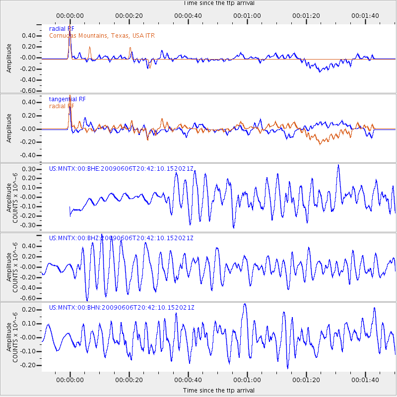
MNTX Cornudas Mountains, Texas, USA - Earthquake Result Viewer
*The percent match for this event was below the threshold and hence no stack was calculated.
| Earthquake location: |
Northern Mid-Atlantic Ridge |
| Earthquake latitude/longitude: |
23.9/-46.1 |
| Earthquake time(UTC): |
2009/06/06 (157) 20:33:28 GMT |
| Earthquake Depth: |
14 km |
| Earthquake Magnitude: |
6.0 MB, 5.7 MS, 6.0 MW, 6.0 MW |
| Earthquake Catalog/Contributor: |
WHDF/NEIC |
|
| Network: |
US United States National Seismic Network |
| Station: |
MNTX Cornudas Mountains, Texas, USA |
| Lat/Lon: |
31.70 N/105.38 W |
| Elevation: |
404 m |
|
| Distance: |
52.5 deg |
| Az: |
292.5 deg |
| Baz: |
82.877 deg |
| Ray Param: |
$rayparam |
*The percent match for this event was below the threshold and hence was not used in the summary stack. |
|
| Radial Match: |
72.97501 % |
| Radial Bump: |
400 |
| Transverse Match: |
65.865944 % |
| Transverse Bump: |
400 |
| SOD ConfigId: |
2648 |
| Insert Time: |
2010-03-05 06:19:07.165 +0000 |
| GWidth: |
2.5 |
| Max Bumps: |
400 |
| Tol: |
0.001 |
|
Signal To Noise
| Channel | StoN | STA | LTA |
| US:MNTX:00:BHZ:20090606T20:42:10.152021Z | 1.9928311 | 1.46642E-7 | 7.358476E-8 |
| US:MNTX:00:BHN:20090606T20:42:10.152021Z | 0.8254126 | 5.6017747E-8 | 6.786636E-8 |
| US:MNTX:00:BHE:20090606T20:42:10.152021Z | 1.1115117 | 6.632765E-8 | 5.967337E-8 |
| Arrivals |
| Ps | |
| PpPs | |
| PsPs/PpSs | |


