You are here: Home > Network List > US - United States National Seismic Network Stations List
> Station MNTX Cornudas Mountains, Texas, USA > Earthquake Result Viewer
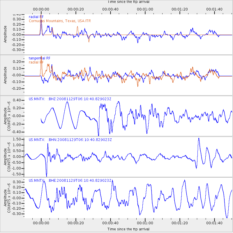
MNTX Cornudas Mountains, Texas, USA - Earthquake Result Viewer
*The percent match for this event was below the threshold and hence no stack was calculated.
| Earthquake location: |
Fiji Islands Region |
| Earthquake latitude/longitude: |
-18.7/-177.7 |
| Earthquake time(UTC): |
2008/11/29 (334) 05:59:16 GMT |
| Earthquake Depth: |
386 km |
| Earthquake Magnitude: |
5.7 MB, 6.0 MW, 5.9 MW |
| Earthquake Catalog/Contributor: |
WHDF/NEIC |
|
| Network: |
US United States National Seismic Network |
| Station: |
MNTX Cornudas Mountains, Texas, USA |
| Lat/Lon: |
31.70 N/105.38 W |
| Elevation: |
404 m |
|
| Distance: |
85.5 deg |
| Az: |
54.559 deg |
| Baz: |
244.952 deg |
| Ray Param: |
$rayparam |
*The percent match for this event was below the threshold and hence was not used in the summary stack. |
|
| Radial Match: |
59.162857 % |
| Radial Bump: |
400 |
| Transverse Match: |
67.13409 % |
| Transverse Bump: |
400 |
| SOD ConfigId: |
2658 |
| Insert Time: |
2010-03-05 06:19:08.624 +0000 |
| GWidth: |
2.5 |
| Max Bumps: |
400 |
| Tol: |
0.001 |
|
Signal To Noise
| Channel | StoN | STA | LTA |
| US:MNTX: :BHN:20081129T06:10:40.829023Z | 5.558363 | 5.9506635E-7 | 1.07057836E-7 |
| US:MNTX: :BHE:20081129T06:10:40.829023Z | 1.6219331 | 1.8097468E-7 | 1.11579624E-7 |
| US:MNTX: :BHZ:20081129T06:10:40.829023Z | 1.1270653 | 2.0714276E-7 | 1.837895E-7 |
| Arrivals |
| Ps | |
| PpPs | |
| PsPs/PpSs | |


