You are here: Home > Network List > CI - Caltech Regional Seismic Network Stations List
> Station MLAC Mammoth Lakes, California, USA > Earthquake Result Viewer
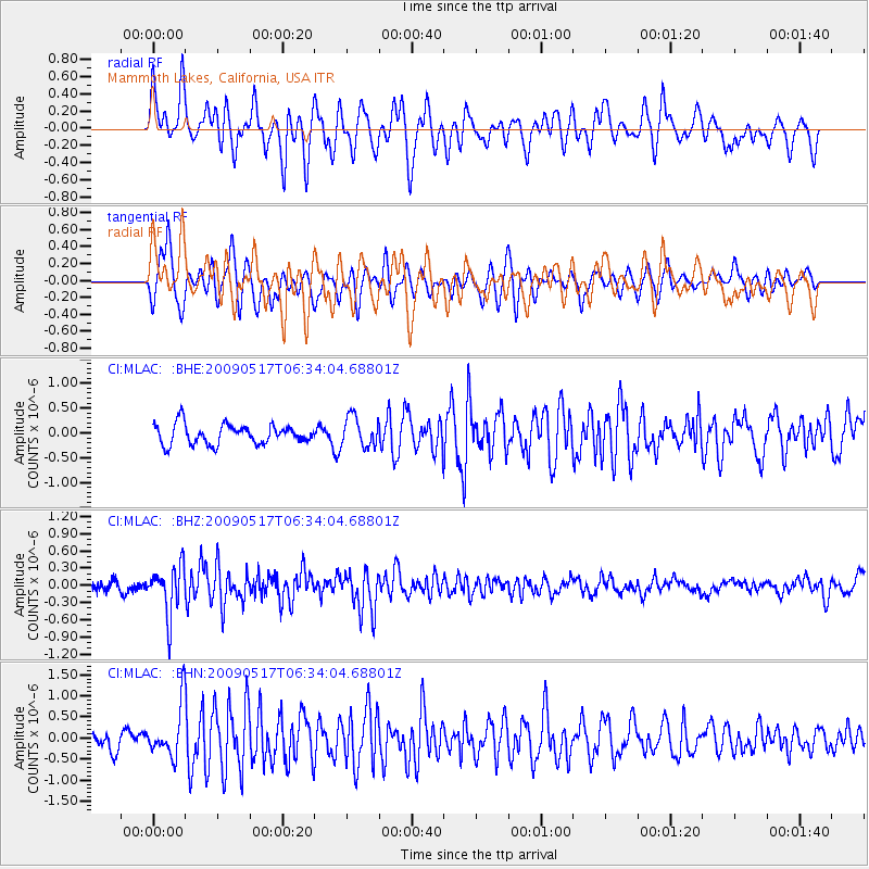
MLAC Mammoth Lakes, California, USA - Earthquake Result Viewer
*The percent match for this event was below the threshold and hence no stack was calculated.
| Earthquake location: |
Tonga Islands |
| Earthquake latitude/longitude: |
-16.8/-173.5 |
| Earthquake time(UTC): |
2009/05/17 (137) 06:23:03 GMT |
| Earthquake Depth: |
67 km |
| Earthquake Magnitude: |
5.5 MB, 5.6 MW, 5.6 MW |
| Earthquake Catalog/Contributor: |
WHDF/NEIC |
|
| Network: |
CI Caltech Regional Seismic Network |
| Station: |
MLAC Mammoth Lakes, California, USA |
| Lat/Lon: |
37.63 N/118.84 W |
| Elevation: |
2134 m |
|
| Distance: |
74.6 deg |
| Az: |
42.192 deg |
| Baz: |
234.112 deg |
| Ray Param: |
$rayparam |
*The percent match for this event was below the threshold and hence was not used in the summary stack. |
|
| Radial Match: |
60.00991 % |
| Radial Bump: |
400 |
| Transverse Match: |
60.606945 % |
| Transverse Bump: |
373 |
| SOD ConfigId: |
2760 |
| Insert Time: |
2010-02-26 00:40:07.099 +0000 |
| GWidth: |
2.5 |
| Max Bumps: |
400 |
| Tol: |
0.001 |
|
Signal To Noise
| Channel | StoN | STA | LTA |
| CI:MLAC: :BHZ:20090517T06:34:04.68801Z | 3.8369496 | 4.2234186E-7 | 1.100723E-7 |
| CI:MLAC: :BHN:20090517T06:34:04.68801Z | 2.9934797 | 6.052442E-7 | 2.0218751E-7 |
| CI:MLAC: :BHE:20090517T06:34:04.68801Z | 1.5296057 | 3.035522E-7 | 1.9845127E-7 |
| Arrivals |
| Ps | |
| PpPs | |
| PsPs/PpSs | |


