You are here: Home > Network List > US - United States National Seismic Network Stations List
> Station MNTX Cornudas Mountains, Texas, USA > Earthquake Result Viewer
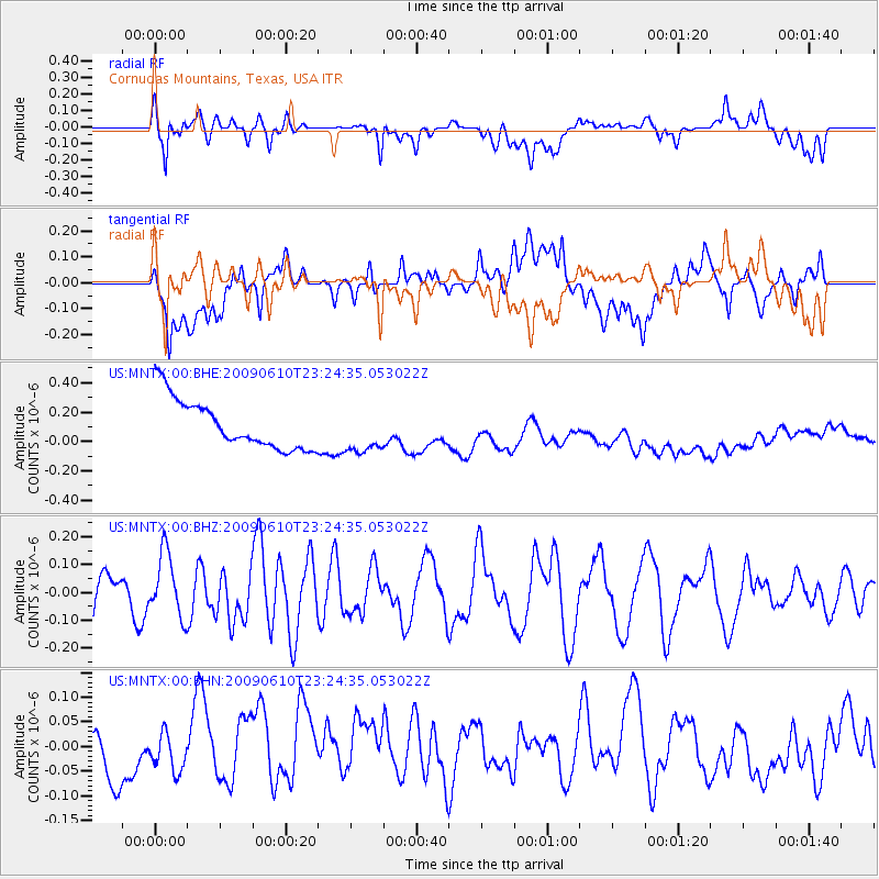
MNTX Cornudas Mountains, Texas, USA - Earthquake Result Viewer
*The percent match for this event was below the threshold and hence no stack was calculated.
| Earthquake location: |
West Chile Rise |
| Earthquake latitude/longitude: |
-41.7/-84.0 |
| Earthquake time(UTC): |
2009/06/10 (161) 23:13:21 GMT |
| Earthquake Depth: |
10 km |
| Earthquake Magnitude: |
5.7 MB, 5.2 MS, 5.7 MW, 5.6 MW |
| Earthquake Catalog/Contributor: |
WHDF/NEIC |
|
| Network: |
US United States National Seismic Network |
| Station: |
MNTX Cornudas Mountains, Texas, USA |
| Lat/Lon: |
31.70 N/105.38 W |
| Elevation: |
404 m |
|
| Distance: |
75.7 deg |
| Az: |
341.287 deg |
| Baz: |
163.633 deg |
| Ray Param: |
$rayparam |
*The percent match for this event was below the threshold and hence was not used in the summary stack. |
|
| Radial Match: |
43.81983 % |
| Radial Bump: |
400 |
| Transverse Match: |
15.346193 % |
| Transverse Bump: |
400 |
| SOD ConfigId: |
2648 |
| Insert Time: |
2010-03-05 06:19:13.856 +0000 |
| GWidth: |
2.5 |
| Max Bumps: |
400 |
| Tol: |
0.001 |
|
Signal To Noise
| Channel | StoN | STA | LTA |
| US:MNTX:00:BHZ:20090610T23:24:35.053022Z | 1.8855425 | 1.1301625E-7 | 5.993832E-8 |
| US:MNTX:00:BHN:20090610T23:24:35.053022Z | 0.7215088 | 3.7911086E-8 | 5.2544173E-8 |
| US:MNTX:00:BHE:20090610T23:24:35.053022Z | 0.9214625 | 1.5405266E-7 | 1.6718278E-7 |
| Arrivals |
| Ps | |
| PpPs | |
| PsPs/PpSs | |


