You are here: Home > Network List > TA - USArray Transportable Network (new EarthScope stations) Stations List
> Station F21K Alatna River, AK, USA > Earthquake Result Viewer
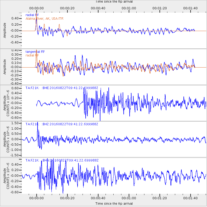
F21K Alatna River, AK, USA - Earthquake Result Viewer
*The percent match for this event was below the threshold and hence no stack was calculated.
| Earthquake location: |
Southeast Of Honshu, Japan |
| Earthquake latitude/longitude: |
29.9/139.1 |
| Earthquake time(UTC): |
2016/08/22 (235) 09:33:08 GMT |
| Earthquake Depth: |
404 km |
| Earthquake Magnitude: |
5.6 MB |
| Earthquake Catalog/Contributor: |
NEIC PDE/NEIC COMCAT |
|
| Network: |
TA USArray Transportable Network (new EarthScope stations) |
| Station: |
F21K Alatna River, AK, USA |
| Lat/Lon: |
67.22 N/153.48 W |
| Elevation: |
597 m |
|
| Distance: |
54.1 deg |
| Az: |
26.353 deg |
| Baz: |
261.874 deg |
| Ray Param: |
$rayparam |
*The percent match for this event was below the threshold and hence was not used in the summary stack. |
|
| Radial Match: |
69.01517 % |
| Radial Bump: |
400 |
| Transverse Match: |
65.79031 % |
| Transverse Bump: |
400 |
| SOD ConfigId: |
11737051 |
| Insert Time: |
2019-04-25 08:06:22.551 +0000 |
| GWidth: |
2.5 |
| Max Bumps: |
400 |
| Tol: |
0.001 |
|
Signal To Noise
| Channel | StoN | STA | LTA |
| TA:F21K: :BHZ:20160822T09:41:22.699988Z | 6.1068306 | 5.081928E-7 | 8.32171E-8 |
| TA:F21K: :BHN:20160822T09:41:22.699988Z | 3.9172792 | 2.1762683E-7 | 5.555561E-8 |
| TA:F21K: :BHE:20160822T09:41:22.699988Z | 5.6656127 | 2.8889093E-7 | 5.0990234E-8 |
| Arrivals |
| Ps | |
| PpPs | |
| PsPs/PpSs | |


