You are here: Home > Network List > US - United States National Seismic Network Stations List
> Station MNTX Cornudas Mountains, Texas, USA > Earthquake Result Viewer
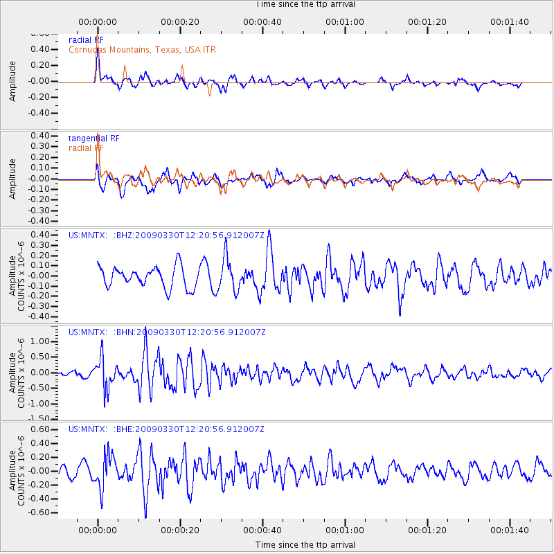
MNTX Cornudas Mountains, Texas, USA - Earthquake Result Viewer
*The percent match for this event was below the threshold and hence no stack was calculated.
| Earthquake location: |
Andreanof Islands, Aleutian Is. |
| Earthquake latitude/longitude: |
51.5/-178.3 |
| Earthquake time(UTC): |
2009/03/30 (089) 12:11:54 GMT |
| Earthquake Depth: |
31 km |
| Earthquake Magnitude: |
6.0 MB, 5.8 MW, 5.7 MW |
| Earthquake Catalog/Contributor: |
WHDF/NEIC |
|
| Network: |
US United States National Seismic Network |
| Station: |
MNTX Cornudas Mountains, Texas, USA |
| Lat/Lon: |
31.70 N/105.38 W |
| Elevation: |
404 m |
|
| Distance: |
55.6 deg |
| Az: |
80.88 deg |
| Baz: |
313.645 deg |
| Ray Param: |
$rayparam |
*The percent match for this event was below the threshold and hence was not used in the summary stack. |
|
| Radial Match: |
58.531063 % |
| Radial Bump: |
400 |
| Transverse Match: |
70.207985 % |
| Transverse Bump: |
400 |
| SOD ConfigId: |
2658 |
| Insert Time: |
2010-03-05 06:19:31.804 +0000 |
| GWidth: |
2.5 |
| Max Bumps: |
400 |
| Tol: |
0.001 |
|
Signal To Noise
| Channel | StoN | STA | LTA |
| US:MNTX: :BHN:20090330T12:20:56.912007Z | 3.8217645 | 4.91127E-7 | 1.2850792E-7 |
| US:MNTX: :BHE:20090330T12:20:56.912007Z | 2.270056 | 2.4538937E-7 | 1.0809838E-7 |
| US:MNTX: :BHZ:20090330T12:20:56.912007Z | 1.6548325 | 1.6550688E-7 | 1.00014276E-7 |
| Arrivals |
| Ps | |
| PpPs | |
| PsPs/PpSs | |


