You are here: Home > Network List > TA - USArray Transportable Network (new EarthScope stations) Stations List
> Station J26L Joseph Creek, AK, USA > Earthquake Result Viewer
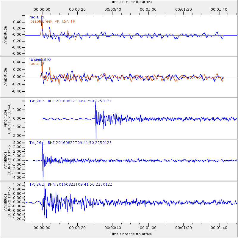
J26L Joseph Creek, AK, USA - Earthquake Result Viewer
*The percent match for this event was below the threshold and hence no stack was calculated.
| Earthquake location: |
Southeast Of Honshu, Japan |
| Earthquake latitude/longitude: |
29.9/139.1 |
| Earthquake time(UTC): |
2016/08/22 (235) 09:33:08 GMT |
| Earthquake Depth: |
404 km |
| Earthquake Magnitude: |
5.6 MB |
| Earthquake Catalog/Contributor: |
NEIC PDE/NEIC COMCAT |
|
| Network: |
TA USArray Transportable Network (new EarthScope stations) |
| Station: |
J26L Joseph Creek, AK, USA |
| Lat/Lon: |
64.50 N/143.56 W |
| Elevation: |
1144 m |
|
| Distance: |
58.0 deg |
| Az: |
29.857 deg |
| Baz: |
272.881 deg |
| Ray Param: |
$rayparam |
*The percent match for this event was below the threshold and hence was not used in the summary stack. |
|
| Radial Match: |
72.858315 % |
| Radial Bump: |
400 |
| Transverse Match: |
73.70907 % |
| Transverse Bump: |
400 |
| SOD ConfigId: |
11737051 |
| Insert Time: |
2019-04-25 08:06:48.943 +0000 |
| GWidth: |
2.5 |
| Max Bumps: |
400 |
| Tol: |
0.001 |
|
Signal To Noise
| Channel | StoN | STA | LTA |
| TA:J26L: :BHZ:20160822T09:41:50.225012Z | 24.234892 | 1.2802752E-6 | 5.282777E-8 |
| TA:J26L: :BHN:20160822T09:41:50.225012Z | 11.776076 | 4.846582E-7 | 4.1156166E-8 |
| TA:J26L: :BHE:20160822T09:41:50.225012Z | 13.93472 | 7.1589045E-7 | 5.1374585E-8 |
| Arrivals |
| Ps | |
| PpPs | |
| PsPs/PpSs | |


