You are here: Home > Network List > US - United States National Seismic Network Stations List
> Station MNTX Cornudas Mountains, Texas, USA > Earthquake Result Viewer
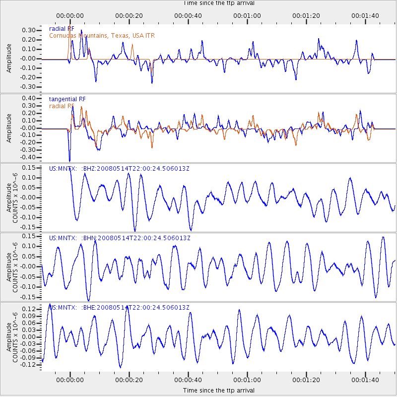
MNTX Cornudas Mountains, Texas, USA - Earthquake Result Viewer
*The percent match for this event was below the threshold and hence no stack was calculated.
| Earthquake location: |
Pacific-Antarctic Ridge |
| Earthquake latitude/longitude: |
-56.8/-142.3 |
| Earthquake time(UTC): |
2008/05/14 (135) 21:47:40 GMT |
| Earthquake Depth: |
10 km |
| Earthquake Magnitude: |
5.7 MW, 5.2 MS, 4.8 MB |
| Earthquake Catalog/Contributor: |
WHDF/NEIC |
|
| Network: |
US United States National Seismic Network |
| Station: |
MNTX Cornudas Mountains, Texas, USA |
| Lat/Lon: |
31.70 N/105.38 W |
| Elevation: |
404 m |
|
| Distance: |
93.5 deg |
| Az: |
30.869 deg |
| Baz: |
199.354 deg |
| Ray Param: |
$rayparam |
*The percent match for this event was below the threshold and hence was not used in the summary stack. |
|
| Radial Match: |
51.534714 % |
| Radial Bump: |
400 |
| Transverse Match: |
35.258354 % |
| Transverse Bump: |
400 |
| SOD ConfigId: |
2504 |
| Insert Time: |
2010-03-05 06:19:41.799 +0000 |
| GWidth: |
2.5 |
| Max Bumps: |
400 |
| Tol: |
0.001 |
|
Signal To Noise
| Channel | StoN | STA | LTA |
| US:MNTX: :BHN:20080514T22:00:24.506013Z | 1.1106379 | 7.214448E-8 | 6.4957696E-8 |
| US:MNTX: :BHE:20080514T22:00:24.506013Z | 0.40044415 | 2.6092902E-8 | 6.51599E-8 |
| US:MNTX: :BHZ:20080514T22:00:24.506013Z | 0.6266546 | 4.4204263E-8 | 7.054007E-8 |
| Arrivals |
| Ps | |
| PpPs | |
| PsPs/PpSs | |


