You are here: Home > Network List > US - United States National Seismic Network Stations List
> Station MNTX Cornudas Mountains, Texas, USA > Earthquake Result Viewer
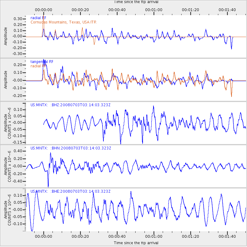
MNTX Cornudas Mountains, Texas, USA - Earthquake Result Viewer
*The percent match for this event was below the threshold and hence no stack was calculated.
| Earthquake location: |
South Of Fiji Islands |
| Earthquake latitude/longitude: |
-23.4/-179.8 |
| Earthquake time(UTC): |
2008/07/03 (185) 03:02:37 GMT |
| Earthquake Depth: |
581 km |
| Earthquake Magnitude: |
5.6 MB, 6.2 MW, 6.2 MW |
| Earthquake Catalog/Contributor: |
WHDF/NEIC |
|
| Network: |
US United States National Seismic Network |
| Station: |
MNTX Cornudas Mountains, Texas, USA |
| Lat/Lon: |
31.70 N/105.38 W |
| Elevation: |
404 m |
|
| Distance: |
89.7 deg |
| Az: |
55.184 deg |
| Baz: |
242.26 deg |
| Ray Param: |
$rayparam |
*The percent match for this event was below the threshold and hence was not used in the summary stack. |
|
| Radial Match: |
66.34317 % |
| Radial Bump: |
400 |
| Transverse Match: |
54.451664 % |
| Transverse Bump: |
363 |
| SOD ConfigId: |
2504 |
| Insert Time: |
2010-03-05 06:19:42.585 +0000 |
| GWidth: |
2.5 |
| Max Bumps: |
400 |
| Tol: |
0.001 |
|
Signal To Noise
| Channel | StoN | STA | LTA |
| US:MNTX: :BHN:20080703T03:14:03.323Z | 3.3975475 | 1.9619884E-7 | 5.7747197E-8 |
| US:MNTX: :BHE:20080703T03:14:03.323Z | 0.78136694 | 4.2160664E-8 | 5.3957574E-8 |
| US:MNTX: :BHZ:20080703T03:14:03.323Z | 1.3281687 | 4.701315E-8 | 3.539697E-8 |
| Arrivals |
| Ps | |
| PpPs | |
| PsPs/PpSs | |


