You are here: Home > Network List > TA - USArray Transportable Network (new EarthScope stations) Stations List
> Station O29M Mount Kennedy, YT, CAN > Earthquake Result Viewer
O29M Mount Kennedy, YT, CAN - Earthquake Result Viewer
| Earthquake location: |
Southeast Of Honshu, Japan |
| Earthquake latitude/longitude: |
29.9/139.1 |
| Earthquake time(UTC): |
2016/08/22 (235) 09:33:08 GMT |
| Earthquake Depth: |
404 km |
| Earthquake Magnitude: |
5.6 MB |
| Earthquake Catalog/Contributor: |
NEIC PDE/NEIC COMCAT |
|
| Network: |
TA USArray Transportable Network (new EarthScope stations) |
| Station: |
O29M Mount Kennedy, YT, CAN |
| Lat/Lon: |
60.30 N/138.58 W |
| Elevation: |
1423 m |
|
| Distance: |
60.8 deg |
| Az: |
34.426 deg |
| Baz: |
279.626 deg |
| Ray Param: |
0.05986847 |
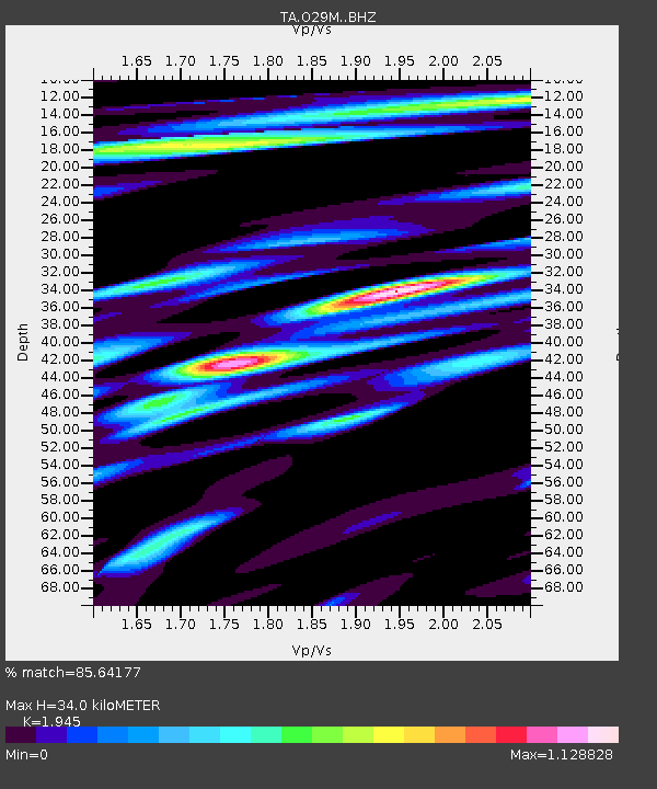
| Estimated Moho Depth: |
34.0 km |
| Estimated Crust Vp/Vs: |
1.95 |
| Assumed Crust Vp: |
6.566 km/s |
| Estimated Crust Vs: |
3.376 km/s |
| Estimated Crust Poisson's Ratio: |
0.32 |
|
| Radial Match: |
85.64177 % |
| Radial Bump: |
400 |
| Transverse Match: |
79.29807 % |
| Transverse Bump: |
400 |
| SOD ConfigId: |
11737051 |
| Insert Time: |
2019-04-25 08:07:23.118 +0000 |
| GWidth: |
2.5 |
| Max Bumps: |
400 |
| Tol: |
0.001 |
|
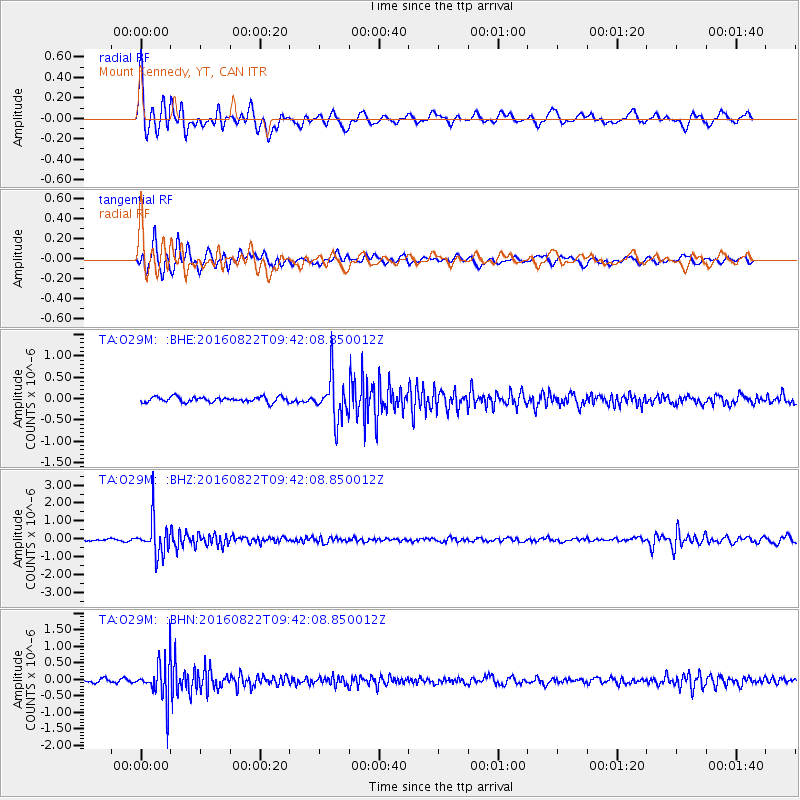
Signal To Noise
| Channel | StoN | STA | LTA |
| TA:O29M: :BHZ:20160822T09:42:08.850012Z | 18.168041 | 9.832942E-7 | 5.412219E-8 |
| TA:O29M: :BHN:20160822T09:42:08.850012Z | 12.006641 | 6.057341E-7 | 5.044992E-8 |
| TA:O29M: :BHE:20160822T09:42:08.850012Z | 7.951263 | 5.042607E-7 | 6.3418945E-8 |
| Arrivals |
| Ps | 5.1 SECOND |
| PpPs | 15 SECOND |
| PsPs/PpSs | 20 SECOND |


