You are here: Home > Network List > US - United States National Seismic Network Stations List
> Station HAWA Hanford, Washington, USA > Earthquake Result Viewer
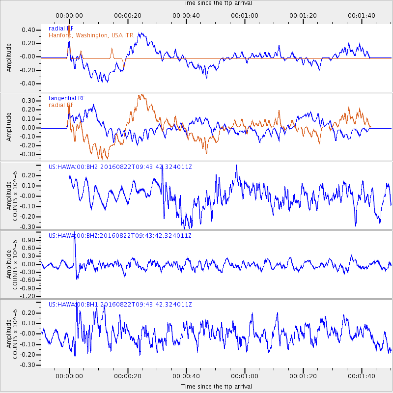
HAWA Hanford, Washington, USA - Earthquake Result Viewer
*The percent match for this event was below the threshold and hence no stack was calculated.
| Earthquake location: |
Southeast Of Honshu, Japan |
| Earthquake latitude/longitude: |
29.9/139.1 |
| Earthquake time(UTC): |
2016/08/22 (235) 09:33:08 GMT |
| Earthquake Depth: |
404 km |
| Earthquake Magnitude: |
5.6 MB |
| Earthquake Catalog/Contributor: |
NEIC PDE/NEIC COMCAT |
|
| Network: |
US United States National Seismic Network |
| Station: |
HAWA Hanford, Washington, USA |
| Lat/Lon: |
46.39 N/119.53 W |
| Elevation: |
364 m |
|
| Distance: |
76.1 deg |
| Az: |
44.349 deg |
| Baz: |
298.716 deg |
| Ray Param: |
$rayparam |
*The percent match for this event was below the threshold and hence was not used in the summary stack. |
|
| Radial Match: |
47.144615 % |
| Radial Bump: |
400 |
| Transverse Match: |
39.935486 % |
| Transverse Bump: |
400 |
| SOD ConfigId: |
11737051 |
| Insert Time: |
2019-04-25 08:08:06.844 +0000 |
| GWidth: |
2.5 |
| Max Bumps: |
400 |
| Tol: |
0.001 |
|
Signal To Noise
| Channel | StoN | STA | LTA |
| US:HAWA:00:BHZ:20160822T09:43:42.324011Z | 4.177081 | 3.4454072E-7 | 8.24836E-8 |
| US:HAWA:00:BH1:20160822T09:43:42.324011Z | 2.8740082 | 1.317315E-7 | 4.5835463E-8 |
| US:HAWA:00:BH2:20160822T09:43:42.324011Z | 1.4921535 | 1.1380887E-7 | 7.627156E-8 |
| Arrivals |
| Ps | |
| PpPs | |
| PsPs/PpSs | |


