You are here: Home > Network List > UW - Pacific Northwest Regional Seismic Network Stations List
> Station PASS Maple Falls, WA, USA > Earthquake Result Viewer
PASS Maple Falls, WA, USA - Earthquake Result Viewer
*The percent match for this event was below the threshold and hence no stack was calculated.
| Earthquake location: |
Southeast Of Honshu, Japan |
| Earthquake latitude/longitude: |
29.9/139.1 |
| Earthquake time(UTC): |
2016/08/22 (235) 09:33:08 GMT |
| Earthquake Depth: |
404 km |
| Earthquake Magnitude: |
5.6 MB |
| Earthquake Catalog/Contributor: |
NEIC PDE/NEIC COMCAT |
|
| Network: |
UW Pacific Northwest Regional Seismic Network |
| Station: |
PASS Maple Falls, WA, USA |
| Lat/Lon: |
49.00 N/122.09 W |
| Elevation: |
174 m |
|
| Distance: |
73.4 deg |
| Az: |
42.782 deg |
| Baz: |
296.421 deg |
| Ray Param: |
$rayparam |
*The percent match for this event was below the threshold and hence was not used in the summary stack. |
|
| Radial Match: |
61.562756 % |
| Radial Bump: |
400 |
| Transverse Match: |
59.365463 % |
| Transverse Bump: |
400 |
| SOD ConfigId: |
11737051 |
| Insert Time: |
2019-04-25 08:08:26.730 +0000 |
| GWidth: |
2.5 |
| Max Bumps: |
400 |
| Tol: |
0.001 |
|
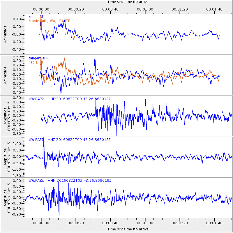
Signal To Noise
| Channel | StoN | STA | LTA |
| UW:PASS: :HHZ:20160822T09:43:26.868018Z | 6.5802436 | 5.2894967E-7 | 8.038451E-8 |
| UW:PASS: :HHN:20160822T09:43:26.868018Z | 2.6377485 | 2.1998173E-7 | 8.339754E-8 |
| UW:PASS: :HHE:20160822T09:43:26.868018Z | 2.5413375 | 2.7331342E-7 | 1.0754707E-7 |
| Arrivals |
| Ps | |
| PpPs | |
| PsPs/PpSs | |


