You are here: Home > Network List > US - United States National Seismic Network Stations List
> Station RLMT Red Lodge, Montana, USA > Earthquake Result Viewer
RLMT Red Lodge, Montana, USA - Earthquake Result Viewer
| Earthquake location: |
Samoa Islands Region |
| Earthquake latitude/longitude: |
-15.5/-172.1 |
| Earthquake time(UTC): |
2009/09/29 (272) 17:48:10 GMT |
| Earthquake Depth: |
18 km |
| Earthquake Magnitude: |
7.1 MB, 8.1 MS, 8.1 MW, 8.0 MW |
| Earthquake Catalog/Contributor: |
WHDF/NEIC |
|
| Network: |
US United States National Seismic Network |
| Station: |
RLMT Red Lodge, Montana, USA |
| Lat/Lon: |
45.12 N/109.27 W |
| Elevation: |
2086 m |
|
| Distance: |
82.9 deg |
| Az: |
39.402 deg |
| Baz: |
239.819 deg |
| Ray Param: |
0.046579648 |
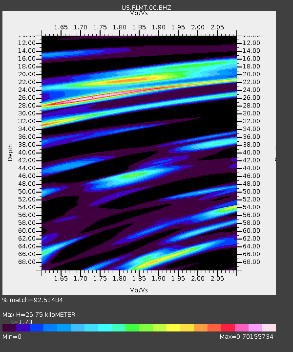
| Estimated Moho Depth: |
25.75 km |
| Estimated Crust Vp/Vs: |
1.73 |
| Assumed Crust Vp: |
6.242 km/s |
| Estimated Crust Vs: |
3.608 km/s |
| Estimated Crust Poisson's Ratio: |
0.25 |
|
| Radial Match: |
92.51484 % |
| Radial Bump: |
400 |
| Transverse Match: |
99.992966 % |
| Transverse Bump: |
4 |
| SOD ConfigId: |
2622 |
| Insert Time: |
2010-03-05 06:20:33.683 +0000 |
| GWidth: |
2.5 |
| Max Bumps: |
400 |
| Tol: |
0.001 |
|

Signal To Noise
| Channel | StoN | STA | LTA |
| US:RLMT:00:BHZ:20090929T18:00:02.857004Z | 8.497291 | 1.5323361E-6 | 1.8033232E-7 |
| US:RLMT:00:BHN:20090929T18:00:02.857004Z | 7.0768933 | 1.1200827E-6 | 1.5827322E-7 |
| US:RLMT:00:BHE:20090929T18:00:02.857004Z | 2.1570482 | 2.9720334E-7 | 1.3778242E-7 |
| Arrivals |
| Ps | 3.1 SECOND |
| PpPs | 11 SECOND |
| PsPs/PpSs | 14 SECOND |


