You are here: Home > Network List > CB - China National Seismic Network Stations List
> Station LZH Lanzhou,Gansu Province > Earthquake Result Viewer
LZH Lanzhou,Gansu Province - Earthquake Result Viewer
| Earthquake location: |
Flores Sea |
| Earthquake latitude/longitude: |
-7.3/122.5 |
| Earthquake time(UTC): |
2016/08/23 (236) 19:39:44 GMT |
| Earthquake Depth: |
528 km |
| Earthquake Magnitude: |
6.0 MB |
| Earthquake Catalog/Contributor: |
NEIC PDE/NEIC COMCAT |
|
| Network: |
CB China National Seismic Network |
| Station: |
LZH Lanzhou,Gansu Province |
| Lat/Lon: |
36.09 N/103.84 E |
| Elevation: |
1560 m |
|
| Distance: |
46.6 deg |
| Az: |
339.146 deg |
| Baz: |
154.152 deg |
| Ray Param: |
0.06809258 |
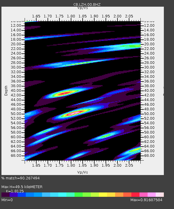
| Estimated Moho Depth: |
49.5 km |
| Estimated Crust Vp/Vs: |
1.81 |
| Assumed Crust Vp: |
6.306 km/s |
| Estimated Crust Vs: |
3.479 km/s |
| Estimated Crust Poisson's Ratio: |
0.28 |
|
| Radial Match: |
90.267494 % |
| Radial Bump: |
400 |
| Transverse Match: |
77.09644 % |
| Transverse Bump: |
400 |
| SOD ConfigId: |
11737051 |
| Insert Time: |
2019-04-25 08:13:05.821 +0000 |
| GWidth: |
2.5 |
| Max Bumps: |
400 |
| Tol: |
0.001 |
|

Signal To Noise
| Channel | StoN | STA | LTA |
| CB:LZH:00:BHZ:20160823T19:46:53.549987Z | 33.771717 | 2.5377517E-6 | 7.514429E-8 |
| CB:LZH:00:BHN:20160823T19:46:53.549987Z | 8.8956175 | 8.7882546E-7 | 9.879308E-8 |
| CB:LZH:00:BHE:20160823T19:46:53.549987Z | 4.8868375 | 4.1435783E-7 | 8.479059E-8 |
| Arrivals |
| Ps | 6.7 SECOND |
| PpPs | 21 SECOND |
| PsPs/PpSs | 28 SECOND |


