You are here: Home > Network List > IW - Intermountain West Stations List
> Station LOHW Long Hollow, Wyoming, USA > Earthquake Result Viewer
LOHW Long Hollow, Wyoming, USA - Earthquake Result Viewer
| Earthquake location: |
Off Coast Of Central Chile |
| Earthquake latitude/longitude: |
-32.3/-72.1 |
| Earthquake time(UTC): |
2015/09/19 (262) 12:52:19 GMT |
| Earthquake Depth: |
11 km |
| Earthquake Magnitude: |
6.2 MWB |
| Earthquake Catalog/Contributor: |
NEIC PDE/NEIC COMCAT |
|
| Network: |
IW Intermountain West |
| Station: |
LOHW Long Hollow, Wyoming, USA |
| Lat/Lon: |
43.61 N/110.60 W |
| Elevation: |
2121 m |
|
| Distance: |
83.4 deg |
| Az: |
332.915 deg |
| Baz: |
147.949 deg |
| Ray Param: |
0.046227653 |
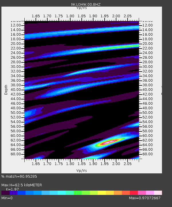
| Estimated Moho Depth: |
62.5 km |
| Estimated Crust Vp/Vs: |
1.97 |
| Assumed Crust Vp: |
6.207 km/s |
| Estimated Crust Vs: |
3.151 km/s |
| Estimated Crust Poisson's Ratio: |
0.33 |
|
| Radial Match: |
90.95285 % |
| Radial Bump: |
400 |
| Transverse Match: |
76.48358 % |
| Transverse Bump: |
400 |
| SOD ConfigId: |
1156111 |
| Insert Time: |
2015-10-03 13:19:24.245 +0000 |
| GWidth: |
2.5 |
| Max Bumps: |
400 |
| Tol: |
0.001 |
|

Signal To Noise
| Channel | StoN | STA | LTA |
| IW:LOHW:00:BHZ:20150919T13:04:15.46397Z | 8.669803 | 3.9879612E-7 | 4.599829E-8 |
| IW:LOHW:00:BH1:20150919T13:04:15.46397Z | 2.0549505 | 1.3969947E-7 | 6.798191E-8 |
| IW:LOHW:00:BH2:20150919T13:04:15.46397Z | 1.4984131 | 9.821967E-8 | 6.554912E-8 |
| Arrivals |
| Ps | 10.0 SECOND |
| PpPs | 29 SECOND |
| PsPs/PpSs | 39 SECOND |


