You are here: Home > Network List > TA - USArray Transportable Network (new EarthScope stations) Stations List
> Station F21K Alatna River, AK, USA > Earthquake Result Viewer
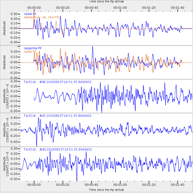
F21K Alatna River, AK, USA - Earthquake Result Viewer
*The percent match for this event was below the threshold and hence no stack was calculated.
| Earthquake location: |
Flores Sea |
| Earthquake latitude/longitude: |
-7.3/122.5 |
| Earthquake time(UTC): |
2016/08/23 (236) 19:39:44 GMT |
| Earthquake Depth: |
528 km |
| Earthquake Magnitude: |
6.0 MB |
| Earthquake Catalog/Contributor: |
NEIC PDE/NEIC COMCAT |
|
| Network: |
TA USArray Transportable Network (new EarthScope stations) |
| Station: |
F21K Alatna River, AK, USA |
| Lat/Lon: |
67.22 N/153.48 W |
| Elevation: |
597 m |
|
| Distance: |
94.4 deg |
| Az: |
22.856 deg |
| Baz: |
261.726 deg |
| Ray Param: |
$rayparam |
*The percent match for this event was below the threshold and hence was not used in the summary stack. |
|
| Radial Match: |
59.069313 % |
| Radial Bump: |
400 |
| Transverse Match: |
51.582767 % |
| Transverse Bump: |
400 |
| SOD ConfigId: |
11737051 |
| Insert Time: |
2019-04-25 08:14:40.918 +0000 |
| GWidth: |
2.5 |
| Max Bumps: |
400 |
| Tol: |
0.001 |
|
Signal To Noise
| Channel | StoN | STA | LTA |
| TA:F21K: :BHZ:20160823T19:51:35.899993Z | 4.2820554 | 2.0573884E-7 | 4.8046747E-8 |
| TA:F21K: :BHN:20160823T19:51:35.899993Z | 1.0460511 | 5.6860088E-8 | 5.4356892E-8 |
| TA:F21K: :BHE:20160823T19:51:35.899993Z | 1.9468354 | 1.2075812E-7 | 6.20279E-8 |
| Arrivals |
| Ps | |
| PpPs | |
| PsPs/PpSs | |


