You are here: Home > Network List > TA - USArray Transportable Network (new EarthScope stations) Stations List
> Station G22K Bettles, AK, USA > Earthquake Result Viewer
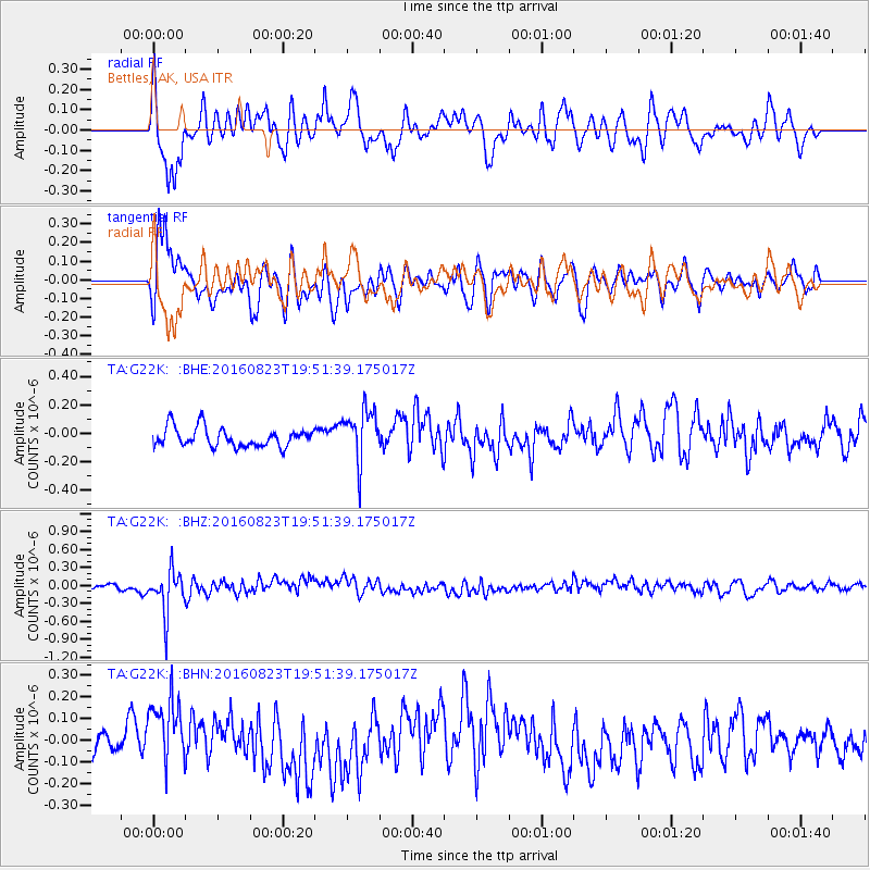
G22K Bettles, AK, USA - Earthquake Result Viewer
*The percent match for this event was below the threshold and hence no stack was calculated.
| Earthquake location: |
Flores Sea |
| Earthquake latitude/longitude: |
-7.3/122.5 |
| Earthquake time(UTC): |
2016/08/23 (236) 19:39:44 GMT |
| Earthquake Depth: |
528 km |
| Earthquake Magnitude: |
6.0 MB |
| Earthquake Catalog/Contributor: |
NEIC PDE/NEIC COMCAT |
|
| Network: |
TA USArray Transportable Network (new EarthScope stations) |
| Station: |
G22K Bettles, AK, USA |
| Lat/Lon: |
66.92 N/151.51 W |
| Elevation: |
205 m |
|
| Distance: |
95.1 deg |
| Az: |
23.256 deg |
| Baz: |
263.51 deg |
| Ray Param: |
$rayparam |
*The percent match for this event was below the threshold and hence was not used in the summary stack. |
|
| Radial Match: |
59.63563 % |
| Radial Bump: |
400 |
| Transverse Match: |
71.3851 % |
| Transverse Bump: |
400 |
| SOD ConfigId: |
11737051 |
| Insert Time: |
2019-04-25 08:14:42.549 +0000 |
| GWidth: |
2.5 |
| Max Bumps: |
400 |
| Tol: |
0.001 |
|
Signal To Noise
| Channel | StoN | STA | LTA |
| TA:G22K: :BHZ:20160823T19:51:39.175017Z | 4.2366633 | 3.5618612E-7 | 8.407232E-8 |
| TA:G22K: :BHN:20160823T19:51:39.175017Z | 2.6755147 | 1.7059861E-7 | 6.376291E-8 |
| TA:G22K: :BHE:20160823T19:51:39.175017Z | 2.7817287 | 1.861395E-7 | 6.691504E-8 |
| Arrivals |
| Ps | |
| PpPs | |
| PsPs/PpSs | |


