You are here: Home > Network List > TA - USArray Transportable Network (new EarthScope stations) Stations List
> Station L20K Farewell, AK, USA > Earthquake Result Viewer
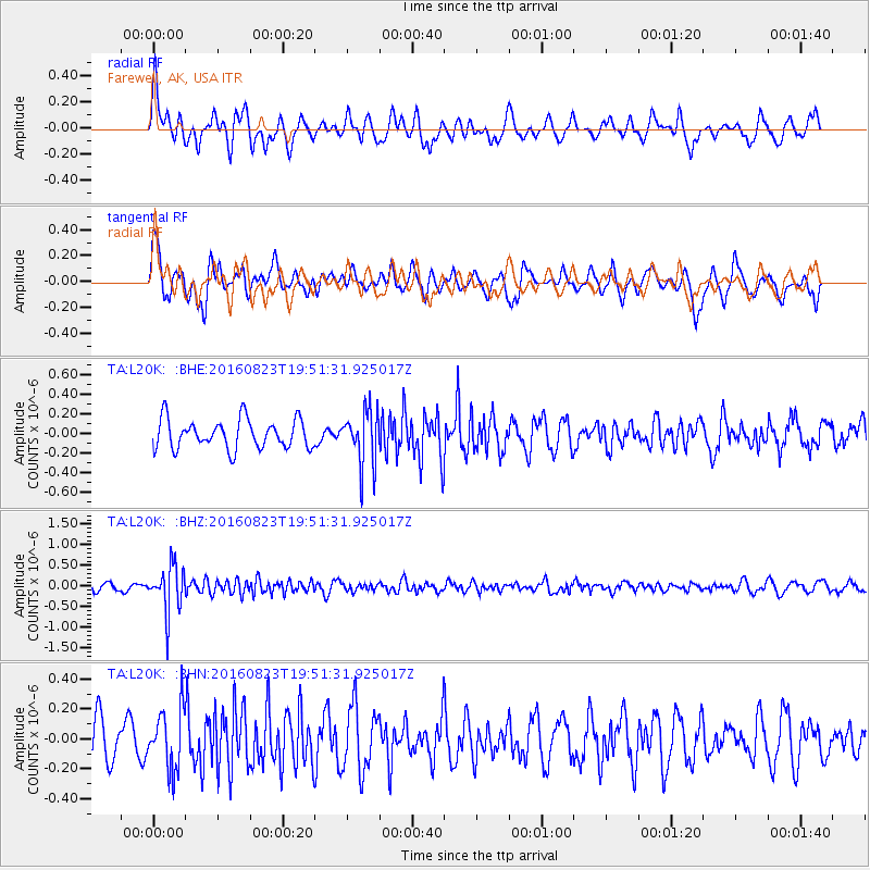
L20K Farewell, AK, USA - Earthquake Result Viewer
*The percent match for this event was below the threshold and hence no stack was calculated.
| Earthquake location: |
Flores Sea |
| Earthquake latitude/longitude: |
-7.3/122.5 |
| Earthquake time(UTC): |
2016/08/23 (236) 19:39:44 GMT |
| Earthquake Depth: |
528 km |
| Earthquake Magnitude: |
6.0 MB |
| Earthquake Catalog/Contributor: |
NEIC PDE/NEIC COMCAT |
|
| Network: |
TA USArray Transportable Network (new EarthScope stations) |
| Station: |
L20K Farewell, AK, USA |
| Lat/Lon: |
62.48 N/153.88 W |
| Elevation: |
673 m |
|
| Distance: |
93.5 deg |
| Az: |
27.551 deg |
| Baz: |
261.045 deg |
| Ray Param: |
$rayparam |
*The percent match for this event was below the threshold and hence was not used in the summary stack. |
|
| Radial Match: |
60.6597 % |
| Radial Bump: |
400 |
| Transverse Match: |
67.487564 % |
| Transverse Bump: |
400 |
| SOD ConfigId: |
11737051 |
| Insert Time: |
2019-04-25 08:14:52.257 +0000 |
| GWidth: |
2.5 |
| Max Bumps: |
400 |
| Tol: |
0.001 |
|
Signal To Noise
| Channel | StoN | STA | LTA |
| TA:L20K: :BHZ:20160823T19:51:31.925017Z | 5.687064 | 5.6164737E-7 | 9.8758754E-8 |
| TA:L20K: :BHN:20160823T19:51:31.925017Z | 1.2300205 | 2.0011196E-7 | 1.6268993E-7 |
| TA:L20K: :BHE:20160823T19:51:31.925017Z | 1.845587 | 2.7331654E-7 | 1.4809194E-7 |
| Arrivals |
| Ps | |
| PpPs | |
| PsPs/PpSs | |


