You are here: Home > Network List > TA - USArray Transportable Network (new EarthScope stations) Stations List
> Station R17K Ugashik Creek, AK, USA > Earthquake Result Viewer
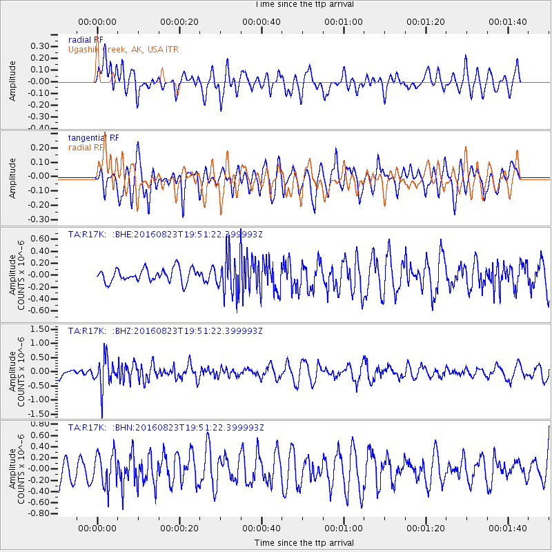
R17K Ugashik Creek, AK, USA - Earthquake Result Viewer
*The percent match for this event was below the threshold and hence no stack was calculated.
| Earthquake location: |
Flores Sea |
| Earthquake latitude/longitude: |
-7.3/122.5 |
| Earthquake time(UTC): |
2016/08/23 (236) 19:39:44 GMT |
| Earthquake Depth: |
528 km |
| Earthquake Magnitude: |
6.0 MB |
| Earthquake Catalog/Contributor: |
NEIC PDE/NEIC COMCAT |
|
| Network: |
TA USArray Transportable Network (new EarthScope stations) |
| Station: |
R17K Ugashik Creek, AK, USA |
| Lat/Lon: |
57.64 N/156.39 W |
| Elevation: |
273 m |
|
| Distance: |
91.4 deg |
| Az: |
32.112 deg |
| Baz: |
258.68 deg |
| Ray Param: |
$rayparam |
*The percent match for this event was below the threshold and hence was not used in the summary stack. |
|
| Radial Match: |
47.951344 % |
| Radial Bump: |
400 |
| Transverse Match: |
39.59565 % |
| Transverse Bump: |
400 |
| SOD ConfigId: |
11737051 |
| Insert Time: |
2019-04-25 08:15:04.004 +0000 |
| GWidth: |
2.5 |
| Max Bumps: |
400 |
| Tol: |
0.001 |
|
Signal To Noise
| Channel | StoN | STA | LTA |
| TA:R17K: :BHZ:20160823T19:51:22.399993Z | 3.1385524 | 5.2189375E-7 | 1.6628485E-7 |
| TA:R17K: :BHN:20160823T19:51:22.399993Z | 1.3949838 | 2.8994145E-7 | 2.0784576E-7 |
| TA:R17K: :BHE:20160823T19:51:22.399993Z | 2.7920291 | 3.075188E-7 | 1.1014169E-7 |
| Arrivals |
| Ps | |
| PpPs | |
| PsPs/PpSs | |


