You are here: Home > Network List > TJ - Tajikistan National Seismic Network Stations List
> Station CHGR Chuyangaron, Tajikistan > Earthquake Result Viewer
CHGR Chuyangaron, Tajikistan - Earthquake Result Viewer
| Earthquake location: |
Flores Sea |
| Earthquake latitude/longitude: |
-7.3/122.5 |
| Earthquake time(UTC): |
2016/08/23 (236) 19:39:44 GMT |
| Earthquake Depth: |
528 km |
| Earthquake Magnitude: |
6.0 MB |
| Earthquake Catalog/Contributor: |
NEIC PDE/NEIC COMCAT |
|
| Network: |
TJ Tajikistan National Seismic Network |
| Station: |
CHGR Chuyangaron, Tajikistan |
| Lat/Lon: |
38.66 N/69.16 E |
| Elevation: |
1049 m |
|
| Distance: |
67.3 deg |
| Az: |
317.126 deg |
| Baz: |
120.447 deg |
| Ray Param: |
0.05520471 |
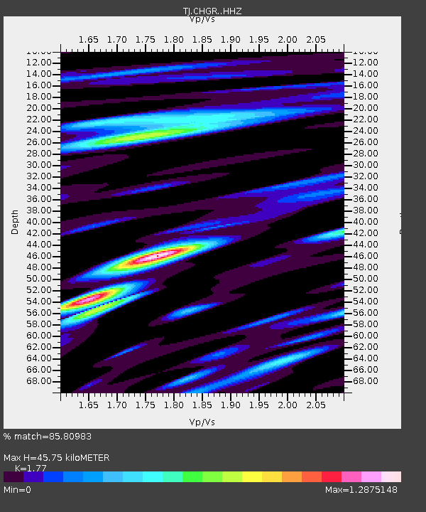
| Estimated Moho Depth: |
45.75 km |
| Estimated Crust Vp/Vs: |
1.77 |
| Assumed Crust Vp: |
6.483 km/s |
| Estimated Crust Vs: |
3.662 km/s |
| Estimated Crust Poisson's Ratio: |
0.27 |
|
| Radial Match: |
85.80983 % |
| Radial Bump: |
400 |
| Transverse Match: |
84.19739 % |
| Transverse Bump: |
400 |
| SOD ConfigId: |
11737051 |
| Insert Time: |
2019-04-25 08:15:04.745 +0000 |
| GWidth: |
2.5 |
| Max Bumps: |
400 |
| Tol: |
0.001 |
|

Signal To Noise
| Channel | StoN | STA | LTA |
| TJ:CHGR: :HHZ:20160823T19:49:15.329985Z | 40.682987 | 4.726892E-6 | 1.1618842E-7 |
| TJ:CHGR: :HHN:20160823T19:49:15.329985Z | 18.926777 | 1.5094342E-6 | 7.975126E-8 |
| TJ:CHGR: :HHE:20160823T19:49:15.329985Z | 18.398066 | 1.6697154E-6 | 9.0754945E-8 |
| Arrivals |
| Ps | 5.6 SECOND |
| PpPs | 19 SECOND |
| PsPs/PpSs | 24 SECOND |


