You are here: Home > Network List > 7A - Mid-Atlantic Geophysical Integrative Collaboration Stations List
> Station ALMA Alma, West Virginia USA > Earthquake Result Viewer
ALMA Alma, West Virginia USA - Earthquake Result Viewer
| Earthquake location: |
Central Italy |
| Earthquake latitude/longitude: |
42.7/13.2 |
| Earthquake time(UTC): |
2016/08/24 (237) 01:36:33 GMT |
| Earthquake Depth: |
10 km |
| Earthquake Magnitude: |
6.2 MWP |
| Earthquake Catalog/Contributor: |
NEIC PDE/NEIC COMCAT |
|
| Network: |
7A Mid-Atlantic Geophysical Integrative Collaboration |
| Station: |
ALMA Alma, West Virginia USA |
| Lat/Lon: |
39.40 N/80.84 W |
| Elevation: |
233 m |
|
| Distance: |
67.2 deg |
| Az: |
303.035 deg |
| Baz: |
52.891 deg |
| Ray Param: |
0.057107158 |
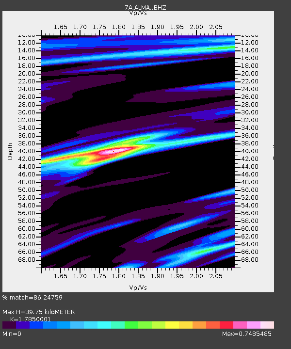
| Estimated Moho Depth: |
39.75 km |
| Estimated Crust Vp/Vs: |
1.79 |
| Assumed Crust Vp: |
6.207 km/s |
| Estimated Crust Vs: |
3.477 km/s |
| Estimated Crust Poisson's Ratio: |
0.27 |
|
| Radial Match: |
86.24759 % |
| Radial Bump: |
400 |
| Transverse Match: |
55.65483 % |
| Transverse Bump: |
400 |
| SOD ConfigId: |
11737051 |
| Insert Time: |
2019-04-25 08:19:34.855 +0000 |
| GWidth: |
2.5 |
| Max Bumps: |
400 |
| Tol: |
0.001 |
|

Signal To Noise
| Channel | StoN | STA | LTA |
| 7A:ALMA: :BHZ:20160824T01:46:56.85001Z | 7.0577726 | 1.1913363E-6 | 1.6879778E-7 |
| 7A:ALMA: :BHN:20160824T01:46:56.85001Z | 1.8809372 | 2.4512934E-7 | 1.3032299E-7 |
| 7A:ALMA: :BHE:20160824T01:46:56.85001Z | 2.535249 | 4.00887E-7 | 1.5812529E-7 |
| Arrivals |
| Ps | 5.2 SECOND |
| PpPs | 17 SECOND |
| PsPs/PpSs | 22 SECOND |


