You are here: Home > Network List > 7A - Mid-Atlantic Geophysical Integrative Collaboration Stations List
> Station LBDL Montpelier, Virginia USA > Earthquake Result Viewer
LBDL Montpelier, Virginia USA - Earthquake Result Viewer
| Earthquake location: |
Central Italy |
| Earthquake latitude/longitude: |
42.7/13.2 |
| Earthquake time(UTC): |
2016/08/24 (237) 01:36:33 GMT |
| Earthquake Depth: |
10 km |
| Earthquake Magnitude: |
6.2 MWP |
| Earthquake Catalog/Contributor: |
NEIC PDE/NEIC COMCAT |
|
| Network: |
7A Mid-Atlantic Geophysical Integrative Collaboration |
| Station: |
LBDL Montpelier, Virginia USA |
| Lat/Lon: |
37.80 N/77.64 W |
| Elevation: |
48 m |
|
| Distance: |
66.2 deg |
| Az: |
300.006 deg |
| Baz: |
53.679 deg |
| Ray Param: |
0.05780062 |
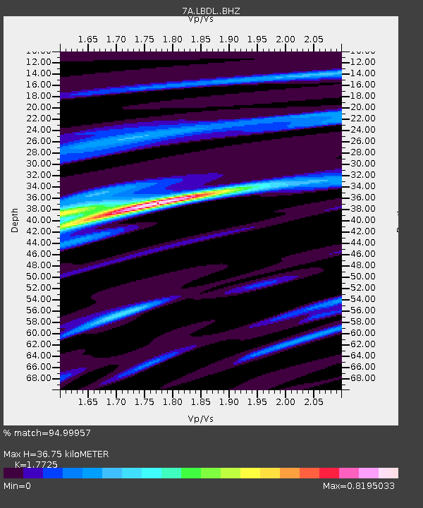
| Estimated Moho Depth: |
36.75 km |
| Estimated Crust Vp/Vs: |
1.77 |
| Assumed Crust Vp: |
6.565 km/s |
| Estimated Crust Vs: |
3.704 km/s |
| Estimated Crust Poisson's Ratio: |
0.27 |
|
| Radial Match: |
94.99957 % |
| Radial Bump: |
302 |
| Transverse Match: |
78.335945 % |
| Transverse Bump: |
400 |
| SOD ConfigId: |
11737051 |
| Insert Time: |
2019-04-25 08:19:44.010 +0000 |
| GWidth: |
2.5 |
| Max Bumps: |
400 |
| Tol: |
0.001 |
|

Signal To Noise
| Channel | StoN | STA | LTA |
| 7A:LBDL: :BHZ:20160824T01:46:50.160007Z | 13.685044 | 9.654717E-7 | 7.054941E-8 |
| 7A:LBDL: :BHN:20160824T01:46:50.160007Z | 4.924516 | 2.2443346E-7 | 4.5574723E-8 |
| 7A:LBDL: :BHE:20160824T01:46:50.160007Z | 8.425913 | 3.4250567E-7 | 4.0649088E-8 |
| Arrivals |
| Ps | 4.5 SECOND |
| PpPs | 15 SECOND |
| PsPs/PpSs | 19 SECOND |


