You are here: Home > Network List > US - United States National Seismic Network Stations List
> Station RLMT Red Lodge, Montana, USA > Earthquake Result Viewer
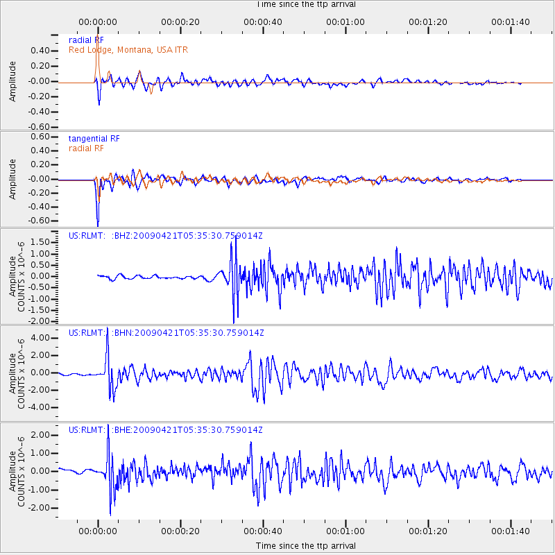
RLMT Red Lodge, Montana, USA - Earthquake Result Viewer
*The percent match for this event was below the threshold and hence no stack was calculated.
| Earthquake location: |
Kuril Islands |
| Earthquake latitude/longitude: |
50.8/155.0 |
| Earthquake time(UTC): |
2009/04/21 (111) 05:26:11 GMT |
| Earthquake Depth: |
152 km |
| Earthquake Magnitude: |
6.0 MB, 6.2 MW, 6.2 MW |
| Earthquake Catalog/Contributor: |
WHDF/NEIC |
|
| Network: |
US United States National Seismic Network |
| Station: |
RLMT Red Lodge, Montana, USA |
| Lat/Lon: |
45.12 N/109.27 W |
| Elevation: |
2086 m |
|
| Distance: |
59.9 deg |
| Az: |
54.502 deg |
| Baz: |
313.179 deg |
| Ray Param: |
$rayparam |
*The percent match for this event was below the threshold and hence was not used in the summary stack. |
|
| Radial Match: |
83.54949 % |
| Radial Bump: |
400 |
| Transverse Match: |
89.91542 % |
| Transverse Bump: |
400 |
| SOD ConfigId: |
2658 |
| Insert Time: |
2010-03-05 06:21:44.662 +0000 |
| GWidth: |
2.5 |
| Max Bumps: |
400 |
| Tol: |
0.001 |
|
Signal To Noise
| Channel | StoN | STA | LTA |
| US:RLMT: :BHN:20090421T05:35:30.759014Z | 15.431716 | 1.8353307E-6 | 1.1893238E-7 |
| US:RLMT: :BHE:20090421T05:35:30.759014Z | 7.2170506 | 9.19497E-7 | 1.274062E-7 |
| US:RLMT: :BHZ:20090421T05:35:30.759014Z | 11.558709 | 7.649765E-7 | 6.6181826E-8 |
| Arrivals |
| Ps | |
| PpPs | |
| PsPs/PpSs | |


