You are here: Home > Network List > CB - China National Seismic Network Stations List
> Station WHN Wuhantai,Hubei Province > Earthquake Result Viewer
WHN Wuhantai,Hubei Province - Earthquake Result Viewer
| Earthquake location: |
Central Italy |
| Earthquake latitude/longitude: |
42.7/13.2 |
| Earthquake time(UTC): |
2016/08/24 (237) 01:36:33 GMT |
| Earthquake Depth: |
10 km |
| Earthquake Magnitude: |
6.2 MWP |
| Earthquake Catalog/Contributor: |
NEIC PDE/NEIC COMCAT |
|
| Network: |
CB China National Seismic Network |
| Station: |
WHN Wuhantai,Hubei Province |
| Lat/Lon: |
30.54 N/114.35 E |
| Elevation: |
80 m |
|
| Distance: |
77.4 deg |
| Az: |
60.147 deg |
| Baz: |
312.19 deg |
| Ray Param: |
0.050360683 |
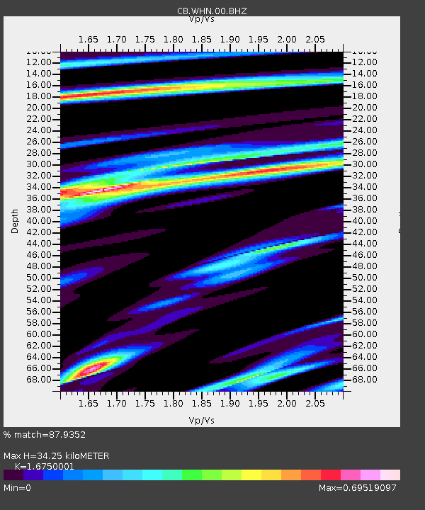
| Estimated Moho Depth: |
34.25 km |
| Estimated Crust Vp/Vs: |
1.68 |
| Assumed Crust Vp: |
6.276 km/s |
| Estimated Crust Vs: |
3.747 km/s |
| Estimated Crust Poisson's Ratio: |
0.22 |
|
| Radial Match: |
87.9352 % |
| Radial Bump: |
398 |
| Transverse Match: |
84.33486 % |
| Transverse Bump: |
400 |
| SOD ConfigId: |
11737051 |
| Insert Time: |
2019-04-25 08:22:27.076 +0000 |
| GWidth: |
2.5 |
| Max Bumps: |
400 |
| Tol: |
0.001 |
|

Signal To Noise
| Channel | StoN | STA | LTA |
| CB:WHN:00:BHZ:20160824T01:47:57.36002Z | 11.864113 | 1.2173227E-6 | 1.02605455E-7 |
| CB:WHN:00:BHN:20160824T01:47:57.36002Z | 2.4386935 | 3.100548E-7 | 1.2713971E-7 |
| CB:WHN:00:BHE:20160824T01:47:57.36002Z | 3.2780278 | 3.3239465E-7 | 1.014008E-7 |
| Arrivals |
| Ps | 3.8 SECOND |
| PpPs | 14 SECOND |
| PsPs/PpSs | 18 SECOND |


