You are here: Home > Network List > N4 - Central and EAstern US Network Stations List
> Station 154A Montrose, GA, USA > Earthquake Result Viewer
154A Montrose, GA, USA - Earthquake Result Viewer
| Earthquake location: |
Central Italy |
| Earthquake latitude/longitude: |
42.7/13.2 |
| Earthquake time(UTC): |
2016/08/24 (237) 01:36:33 GMT |
| Earthquake Depth: |
10 km |
| Earthquake Magnitude: |
6.2 MWP |
| Earthquake Catalog/Contributor: |
NEIC PDE/NEIC COMCAT |
|
| Network: |
N4 Central and EAstern US Network |
| Station: |
154A Montrose, GA, USA |
| Lat/Lon: |
32.61 N/83.11 W |
| Elevation: |
111 m |
|
| Distance: |
72.9 deg |
| Az: |
298.617 deg |
| Baz: |
50.049 deg |
| Ray Param: |
0.053375807 |
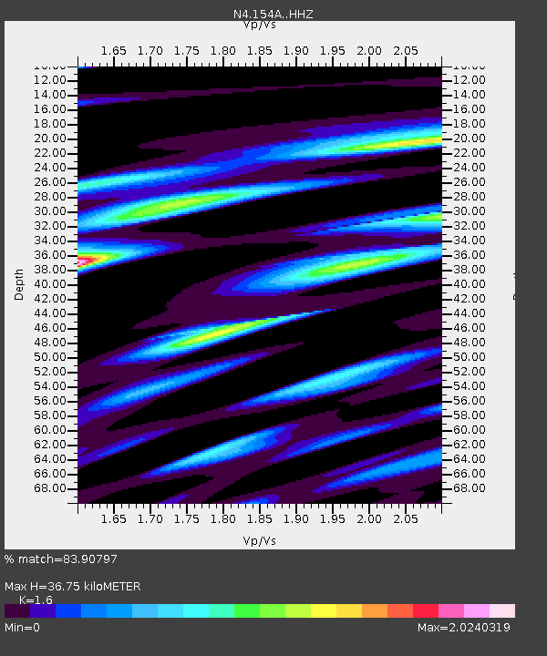
| Estimated Moho Depth: |
36.75 km |
| Estimated Crust Vp/Vs: |
1.60 |
| Assumed Crust Vp: |
6.565 km/s |
| Estimated Crust Vs: |
4.103 km/s |
| Estimated Crust Poisson's Ratio: |
0.18 |
|
| Radial Match: |
83.90797 % |
| Radial Bump: |
400 |
| Transverse Match: |
47.921623 % |
| Transverse Bump: |
400 |
| SOD ConfigId: |
11737051 |
| Insert Time: |
2019-04-25 08:26:24.979 +0000 |
| GWidth: |
2.5 |
| Max Bumps: |
400 |
| Tol: |
0.001 |
|

Signal To Noise
| Channel | StoN | STA | LTA |
| N4:154A: :HHZ:20160824T01:47:31.540012Z | 7.7037125 | 7.941688E-7 | 1.0308911E-7 |
| N4:154A: :HHN:20160824T01:47:31.540012Z | 2.3052716 | 4.679961E-7 | 2.0301125E-7 |
| N4:154A: :HHE:20160824T01:47:31.540012Z | 1.525087 | 5.248433E-7 | 3.441399E-7 |
| Arrivals |
| Ps | 3.5 SECOND |
| PpPs | 14 SECOND |
| PsPs/PpSs | 17 SECOND |


