You are here: Home > Network List > N4 - Central and EAstern US Network Stations List
> Station G65A Princeton, ME, USA > Earthquake Result Viewer
G65A Princeton, ME, USA - Earthquake Result Viewer
| Earthquake location: |
Central Italy |
| Earthquake latitude/longitude: |
42.7/13.2 |
| Earthquake time(UTC): |
2016/08/24 (237) 01:36:33 GMT |
| Earthquake Depth: |
10 km |
| Earthquake Magnitude: |
6.2 MWP |
| Earthquake Catalog/Contributor: |
NEIC PDE/NEIC COMCAT |
|
| Network: |
N4 Central and EAstern US Network |
| Station: |
G65A Princeton, ME, USA |
| Lat/Lon: |
45.20 N/67.56 W |
| Elevation: |
78 m |
|
| Distance: |
55.8 deg |
| Az: |
302.485 deg |
| Baz: |
61.561 deg |
| Ray Param: |
0.06454805 |
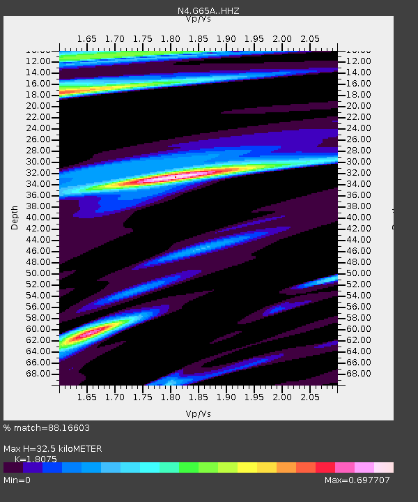
| Estimated Moho Depth: |
32.5 km |
| Estimated Crust Vp/Vs: |
1.81 |
| Assumed Crust Vp: |
6.419 km/s |
| Estimated Crust Vs: |
3.551 km/s |
| Estimated Crust Poisson's Ratio: |
0.28 |
|
| Radial Match: |
88.16603 % |
| Radial Bump: |
387 |
| Transverse Match: |
59.051453 % |
| Transverse Bump: |
400 |
| SOD ConfigId: |
11737051 |
| Insert Time: |
2019-04-25 08:26:51.136 +0000 |
| GWidth: |
2.5 |
| Max Bumps: |
400 |
| Tol: |
0.001 |
|

Signal To Noise
| Channel | StoN | STA | LTA |
| N4:G65A: :HHZ:20160824T01:45:40.019993Z | 9.614047 | 1.1194506E-6 | 1.1643906E-7 |
| N4:G65A: :HHN:20160824T01:45:40.019993Z | 2.371828 | 3.5836246E-7 | 1.5109124E-7 |
| N4:G65A: :HHE:20160824T01:45:40.019993Z | 4.050726 | 5.8418465E-7 | 1.4421727E-7 |
| Arrivals |
| Ps | 4.3 SECOND |
| PpPs | 14 SECOND |
| PsPs/PpSs | 18 SECOND |


