You are here: Home > Network List > N4 - Central and EAstern US Network Stations List
> Station K43A Burlington, WI, USA > Earthquake Result Viewer
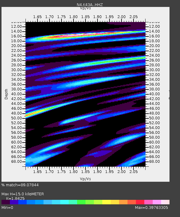
K43A Burlington, WI, USA - Earthquake Result Viewer
| Earthquake location: |
Central Italy |
| Earthquake latitude/longitude: |
42.7/13.2 |
| Earthquake time(UTC): |
2016/08/24 (237) 01:36:33 GMT |
| Earthquake Depth: |
10 km |
| Earthquake Magnitude: |
6.2 MWP |
| Earthquake Catalog/Contributor: |
NEIC PDE/NEIC COMCAT |
|
| Network: |
N4 Central and EAstern US Network |
| Station: |
K43A Burlington, WI, USA |
| Lat/Lon: |
42.70 N/88.33 W |
| Elevation: |
264 m |
|
| Distance: |
69.6 deg |
| Az: |
309.593 deg |
| Baz: |
50.397 deg |
| Ray Param: |
0.055532012 |
| Estimated Moho Depth: |
15.0 km |
| Estimated Crust Vp/Vs: |
1.84 |
| Assumed Crust Vp: |
6.571 km/s |
| Estimated Crust Vs: |
3.566 km/s |
| Estimated Crust Poisson's Ratio: |
0.29 |
|
| Radial Match: |
89.07844 % |
| Radial Bump: |
264 |
| Transverse Match: |
53.16319 % |
| Transverse Bump: |
389 |
| SOD ConfigId: |
11737051 |
| Insert Time: |
2019-04-25 08:27:05.012 +0000 |
| GWidth: |
2.5 |
| Max Bumps: |
400 |
| Tol: |
0.001 |
|

Signal To Noise
| Channel | StoN | STA | LTA |
| N4:K43A: :HHZ:20160824T01:47:11.85001Z | 7.572066 | 1.0357878E-6 | 1.3679065E-7 |
| N4:K43A: :HHN:20160824T01:47:11.85001Z | 3.4718668 | 4.0294594E-7 | 1.1606031E-7 |
| N4:K43A: :HHE:20160824T01:47:11.85001Z | 3.9013383 | 3.713308E-7 | 9.518036E-8 |
| Arrivals |
| Ps | 2.0 SECOND |
| PpPs | 6.2 SECOND |
| PsPs/PpSs | 8.2 SECOND |


