You are here: Home > Network List > US - United States National Seismic Network Stations List
> Station OGNE Ogallala, Nebraska, USA > Earthquake Result Viewer
OGNE Ogallala, Nebraska, USA - Earthquake Result Viewer
| Earthquake location: |
Windward Islands |
| Earthquake latitude/longitude: |
15.0/-61.3 |
| Earthquake time(UTC): |
2007/11/29 (333) 19:00:19 GMT |
| Earthquake Depth: |
148 km |
| Earthquake Magnitude: |
6.9 MB, 7.4 MW, 7.4 MW |
| Earthquake Catalog/Contributor: |
WHDF/NEIC |
|
| Network: |
US United States National Seismic Network |
| Station: |
OGNE Ogallala, Nebraska, USA |
| Lat/Lon: |
40.95 N/102.03 W |
| Elevation: |
0.0 m |
|
| Distance: |
43.8 deg |
| Az: |
314.354 deg |
| Baz: |
114.177 deg |
| Ray Param: |
0.07179747 |
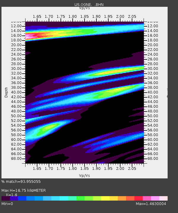
| Estimated Moho Depth: |
16.75 km |
| Estimated Crust Vp/Vs: |
1.60 |
| Assumed Crust Vp: |
6.483 km/s |
| Estimated Crust Vs: |
4.052 km/s |
| Estimated Crust Poisson's Ratio: |
0.18 |
|
| Radial Match: |
93.955055 % |
| Radial Bump: |
400 |
| Transverse Match: |
88.29235 % |
| Transverse Bump: |
400 |
| SOD ConfigId: |
2564 |
| Insert Time: |
2010-03-05 06:23:12.046 +0000 |
| GWidth: |
2.5 |
| Max Bumps: |
400 |
| Tol: |
0.001 |
|

Signal To Noise
| Channel | StoN | STA | LTA |
| US:OGNE: :BHN:20071129T19:07:40.099005Z | 3.491326 | 1.4976865E-6 | 4.2897358E-7 |
| US:OGNE: :BHE:20071129T19:07:40.099005Z | 15.715685 | 8.5162965E-6 | 5.418979E-7 |
| US:OGNE: :BHZ:20071129T19:07:40.100012Z | 54.399593 | 1.892371E-5 | 3.478649E-7 |
| Arrivals |
| Ps | 1.7 SECOND |
| PpPs | 6.2 SECOND |
| PsPs/PpSs | 7.9 SECOND |


