You are here: Home > Network List > US - United States National Seismic Network Stations List
> Station OGNE Ogallala, Nebraska, USA > Earthquake Result Viewer
OGNE Ogallala, Nebraska, USA - Earthquake Result Viewer
| Earthquake location: |
Kuril Islands |
| Earthquake latitude/longitude: |
45.8/150.1 |
| Earthquake time(UTC): |
2007/09/03 (246) 16:14:53 GMT |
| Earthquake Depth: |
94 km |
| Earthquake Magnitude: |
6.3 MB, 6.2 MW, 6.2 ME |
| Earthquake Catalog/Contributor: |
WHDF/NEIC |
|
| Network: |
US United States National Seismic Network |
| Station: |
OGNE Ogallala, Nebraska, USA |
| Lat/Lon: |
40.95 N/102.03 W |
| Elevation: |
0.0 m |
|
| Distance: |
72.3 deg |
| Az: |
49.166 deg |
| Baz: |
315.71 deg |
| Ray Param: |
0.053524487 |
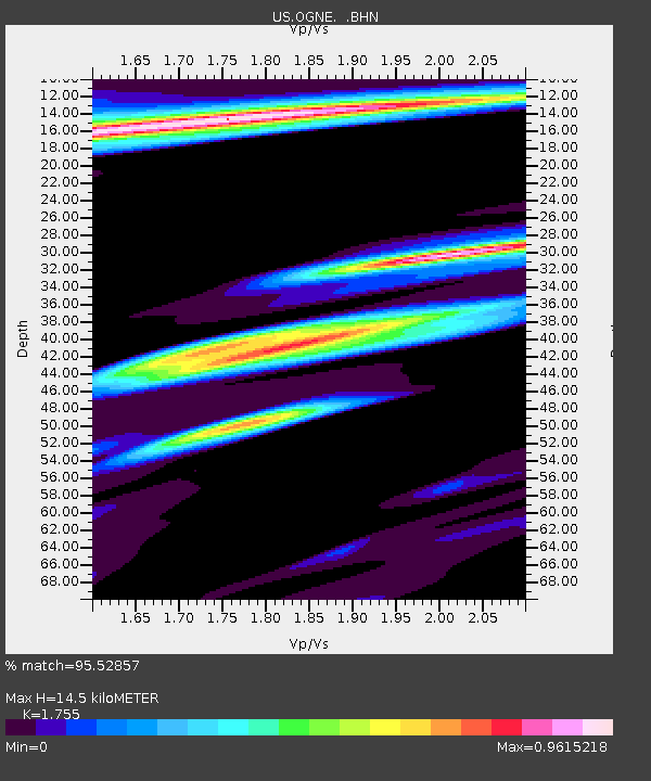
| Estimated Moho Depth: |
14.5 km |
| Estimated Crust Vp/Vs: |
1.75 |
| Assumed Crust Vp: |
6.483 km/s |
| Estimated Crust Vs: |
3.694 km/s |
| Estimated Crust Poisson's Ratio: |
0.26 |
|
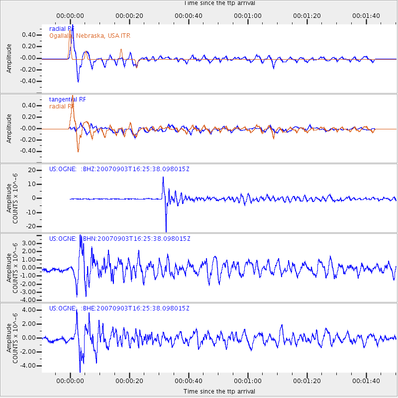
| Radial Match: |
95.52857 % |
| Radial Bump: |
295 |
| Transverse Match: |
71.75994 % |
| Transverse Bump: |
400 |
| SOD ConfigId: |
2564 |
| Insert Time: |
2010-03-05 06:23:20.042 +0000 |
| GWidth: |
2.5 |
| Max Bumps: |
400 |
| Tol: |
0.001 |
|
Signal To Noise
| Channel | StoN | STA | LTA |
| US:OGNE: :BHN:20070903T16:25:38.098015Z | 4.858584 | 1.7910962E-6 | 3.6864574E-7 |
| US:OGNE: :BHE:20070903T16:25:38.098015Z | 7.8063993 | 1.9468202E-6 | 2.4938774E-7 |
| US:OGNE: :BHZ:20070903T16:25:38.098015Z | 55.318058 | 6.450491E-6 | 1.16607325E-7 |
| Arrivals |
| Ps | 1.8 SECOND |
| PpPs | 5.9 SECOND |
| PsPs/PpSs | 7.7 SECOND |


