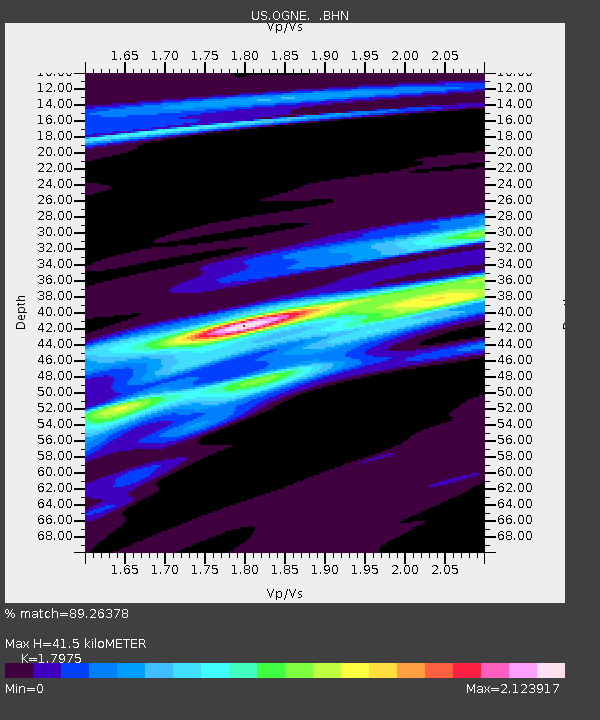
OGNE Ogallala, Nebraska, USA - Earthquake Result Viewer

Earthquake location: Andreanof Islands, Aleutian Is.
Earthquake latitude/longitude: 51.9/-179.2
Earthquake time(UTC): 2008/04/16 (107) 05:54:19 GMT
Earthquake Depth: 13 km
Earthquake Magnitude: 6.1 MB, 6.5 MS, 6.6 MW, 6.6 MW
Earthquake Catalog/Contributor: WHDF/NEIC
Network: US United States National Seismic Network
Station: OGNE Ogallala, Nebraska, USA
Lat/Lon: 40.95 N/102.03 W
Elevation: 0.0 m
Distance: 51.9 deg
Az: 69.759 deg
Baz: 309.843 deg
Ray Param: 0.067092024
Estimated Moho Depth: 41.5 km
Estimated Crust Vp/Vs: 1.80
Assumed Crust Vp: 6.483 km/s
Estimated Crust Vs: 3.606 km/s
Estimated Crust Poisson's Ratio: 0.28
Radial Match: 89.26378 %
Radial Bump: 384
Transverse Match: 60.314804 %
Transverse Bump: 400
SOD ConfigId: 2504
Insert Time: 2010-03-05 06:23:31.175 +0000
GWidth: 2.5
Max Bumps: 400
Tol: 0.001

Signal To Noise

ChannelStoNSTALTA
US:OGNE: :BHN:20080416T06:02:56.973997Z3.15139276.6590593E-72.1130528E-7
US:OGNE: :BHE:20080416T06:02:56.973997Z1.24230077.523996E-76.0565014E-7
US:OGNE: :BHZ:20080416T06:02:56.973997Z1.71145346.9766475E-74.0764462E-7
Arrivals
Ps5.4 SECOND
PpPs17 SECOND
PsPs/PpSs22 SECOND