You are here: Home > Network List > OK - Oklahoma Seismic Network Stations List
> Station X37A Clayton, Oklahoma, USA > Earthquake Result Viewer
X37A Clayton, Oklahoma, USA - Earthquake Result Viewer
| Earthquake location: |
Central Italy |
| Earthquake latitude/longitude: |
42.7/13.2 |
| Earthquake time(UTC): |
2016/08/24 (237) 01:36:33 GMT |
| Earthquake Depth: |
10 km |
| Earthquake Magnitude: |
6.2 MWP |
| Earthquake Catalog/Contributor: |
NEIC PDE/NEIC COMCAT |
|
| Network: |
OK Oklahoma Seismic Network |
| Station: |
X37A Clayton, Oklahoma, USA |
| Lat/Lon: |
34.59 N/95.37 W |
| Elevation: |
207 m |
|
| Distance: |
79.1 deg |
| Az: |
307.205 deg |
| Baz: |
45.358 deg |
| Ray Param: |
0.049171448 |
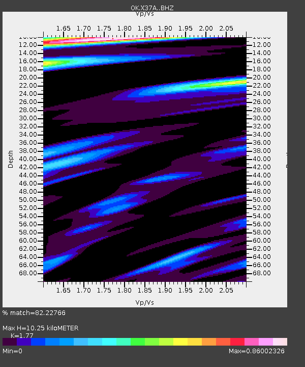
| Estimated Moho Depth: |
10.25 km |
| Estimated Crust Vp/Vs: |
1.77 |
| Assumed Crust Vp: |
6.498 km/s |
| Estimated Crust Vs: |
3.671 km/s |
| Estimated Crust Poisson's Ratio: |
0.27 |
|
| Radial Match: |
82.22766 % |
| Radial Bump: |
400 |
| Transverse Match: |
66.77357 % |
| Transverse Bump: |
400 |
| SOD ConfigId: |
11737051 |
| Insert Time: |
2019-04-25 08:29:14.137 +0000 |
| GWidth: |
2.5 |
| Max Bumps: |
400 |
| Tol: |
0.001 |
|

Signal To Noise
| Channel | StoN | STA | LTA |
| OK:X37A: :BHZ:20160824T01:48:07.124973Z | 5.5953884 | 1.0005728E-6 | 1.7882097E-7 |
| OK:X37A: :BHN:20160824T01:48:07.124973Z | 1.7635036 | 1.2569569E-7 | 7.127612E-8 |
| OK:X37A: :BHE:20160824T01:48:07.124973Z | 1.0761575 | 1.1473297E-7 | 1.0661355E-7 |
| Arrivals |
| Ps | 1.3 SECOND |
| PpPs | 4.2 SECOND |
| PsPs/PpSs | 5.5 SECOND |


