You are here: Home > Network List > US - United States National Seismic Network Stations List
> Station OGNE Ogallala, Nebraska, USA > Earthquake Result Viewer
OGNE Ogallala, Nebraska, USA - Earthquake Result Viewer
| Earthquake location: |
Norwegian Sea |
| Earthquake latitude/longitude: |
72.2/0.9 |
| Earthquake time(UTC): |
2009/08/20 (232) 06:35:04 GMT |
| Earthquake Depth: |
6.0 km |
| Earthquake Magnitude: |
5.9 MB, 5.7 MS, 6.0 MW, 6.0 MW |
| Earthquake Catalog/Contributor: |
WHDF/NEIC |
|
| Network: |
US United States National Seismic Network |
| Station: |
OGNE Ogallala, Nebraska, USA |
| Lat/Lon: |
40.95 N/102.03 W |
| Elevation: |
0.0 m |
|
| Distance: |
55.3 deg |
| Az: |
296.164 deg |
| Baz: |
21.372 deg |
| Ray Param: |
0.064873785 |
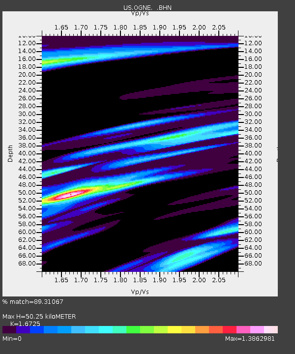
| Estimated Moho Depth: |
50.25 km |
| Estimated Crust Vp/Vs: |
1.67 |
| Assumed Crust Vp: |
6.483 km/s |
| Estimated Crust Vs: |
3.876 km/s |
| Estimated Crust Poisson's Ratio: |
0.22 |
|
| Radial Match: |
89.31067 % |
| Radial Bump: |
289 |
| Transverse Match: |
80.89076 % |
| Transverse Bump: |
395 |
| SOD ConfigId: |
2622 |
| Insert Time: |
2010-03-05 06:24:03.420 +0000 |
| GWidth: |
2.5 |
| Max Bumps: |
400 |
| Tol: |
0.001 |
|
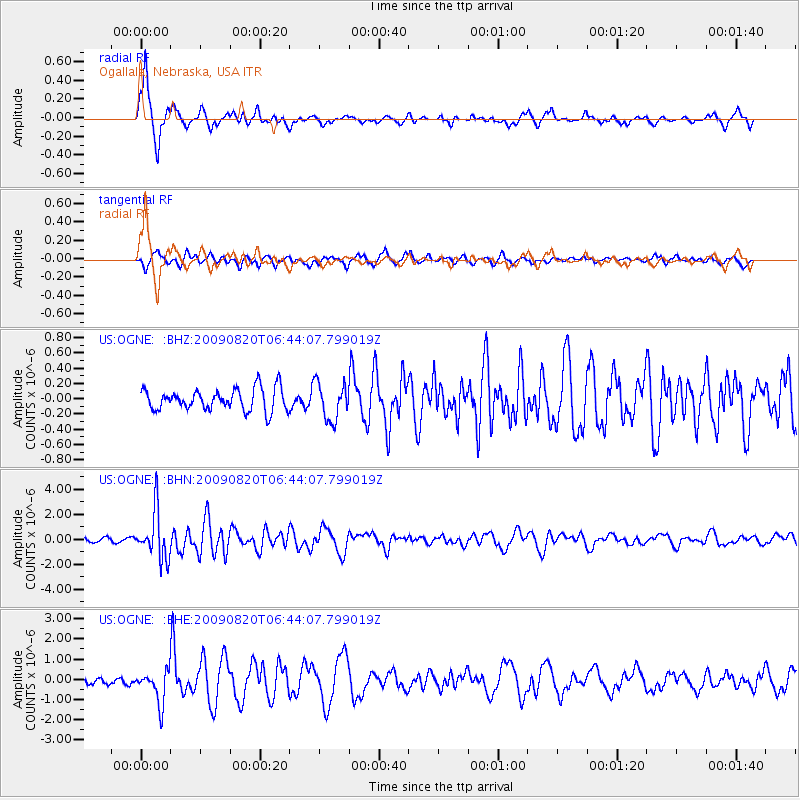
Signal To Noise
| Channel | StoN | STA | LTA |
| US:OGNE: :BHN:20090820T06:44:07.799019Z | 13.36069 | 1.9038564E-6 | 1.4249686E-7 |
| US:OGNE: :BHE:20090820T06:44:07.799019Z | 3.8735147 | 8.6508754E-7 | 2.2333401E-7 |
| US:OGNE: :BHZ:20090820T06:44:07.799019Z | 1.6938193 | 2.412035E-7 | 1.4240216E-7 |
| Arrivals |
| Ps | 5.5 SECOND |
| PpPs | 20 SECOND |
| PsPs/PpSs | 25 SECOND |


