You are here: Home > Network List > US - United States National Seismic Network Stations List
> Station OGNE Ogallala, Nebraska, USA > Earthquake Result Viewer
OGNE Ogallala, Nebraska, USA - Earthquake Result Viewer

| Earthquake location: |
Near Coast Of Venezuela |
| Earthquake latitude/longitude: |
10.7/-67.9 |
| Earthquake time(UTC): |
2009/09/12 (255) 20:06:24 GMT |
| Earthquake Depth: |
10 km |
| Earthquake Magnitude: |
6.3 MB, 6.4 MS, 6.3 MW, 6.3 MW |
| Earthquake Catalog/Contributor: |
WHDF/NEIC |
|
| Network: |
US United States National Seismic Network |
| Station: |
OGNE Ogallala, Nebraska, USA |
| Lat/Lon: |
40.95 N/102.03 W |
| Elevation: |
0.0 m |
|
| Distance: |
42.5 deg |
| Az: |
321.066 deg |
| Baz: |
125.379 deg |
| Ray Param: |
0.07311947 |
| Estimated Moho Depth: |
15.5 km |
| Estimated Crust Vp/Vs: |
1.71 |
| Assumed Crust Vp: |
6.483 km/s |
| Estimated Crust Vs: |
3.797 km/s |
| Estimated Crust Poisson's Ratio: |
0.24 |
|
| Radial Match: |
94.06381 % |
| Radial Bump: |
331 |
| Transverse Match: |
66.596794 % |
| Transverse Bump: |
392 |
| SOD ConfigId: |
2622 |
| Insert Time: |
2010-03-05 06:24:09.987 +0000 |
| GWidth: |
2.5 |
| Max Bumps: |
400 |
| Tol: |
0.001 |
|
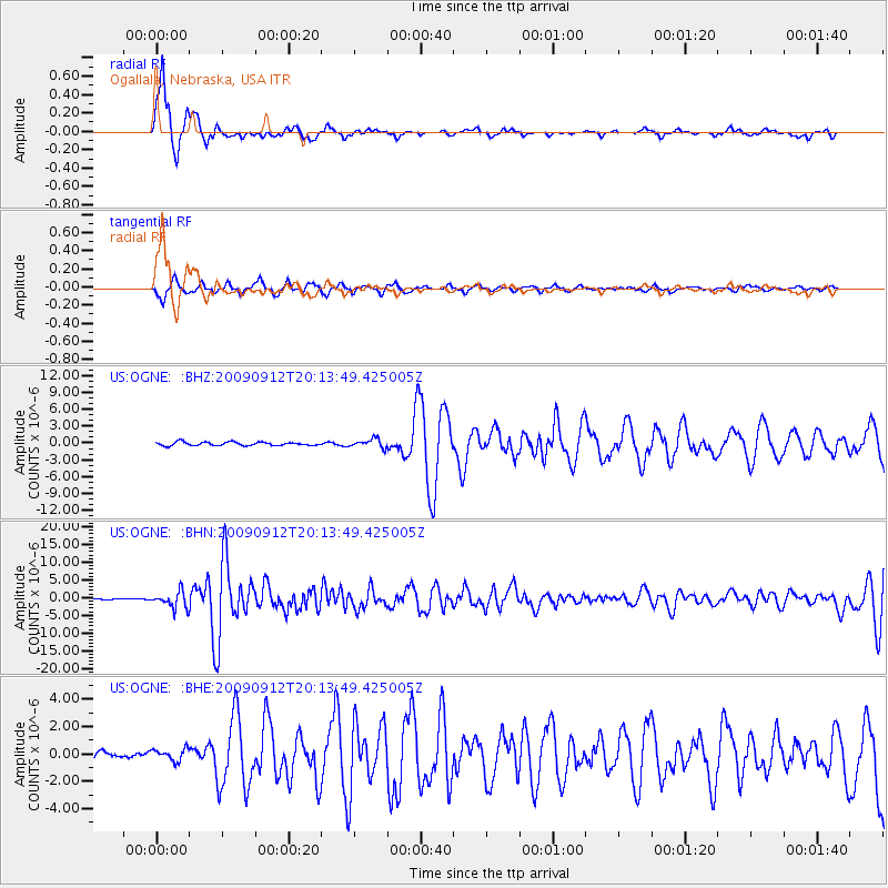
Signal To Noise
| Channel | StoN | STA | LTA |
| US:OGNE: :BHN:20090912T20:13:49.425005Z | 14.420201 | 2.293354E-6 | 1.5903758E-7 |
| US:OGNE: :BHE:20090912T20:13:49.425005Z | 1.7042886 | 4.422425E-7 | 2.5948805E-7 |
| US:OGNE: :BHZ:20090912T20:13:49.425005Z | 2.534386 | 7.8514427E-7 | 3.0979666E-7 |
| Arrivals |
| Ps | 1.8 SECOND |
| PpPs | 6.0 SECOND |
| PsPs/PpSs | 7.8 SECOND |


