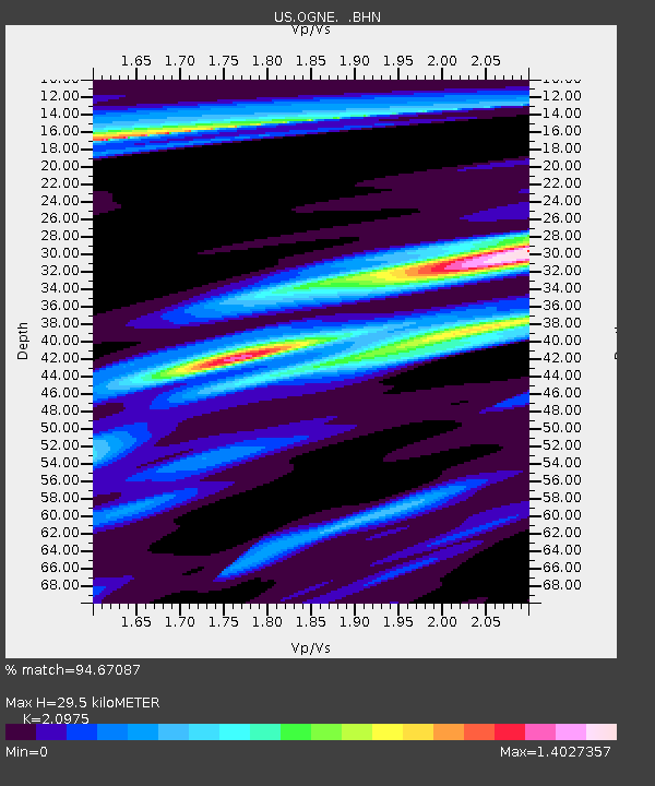
OGNE Ogallala, Nebraska, USA - Earthquake Result Viewer
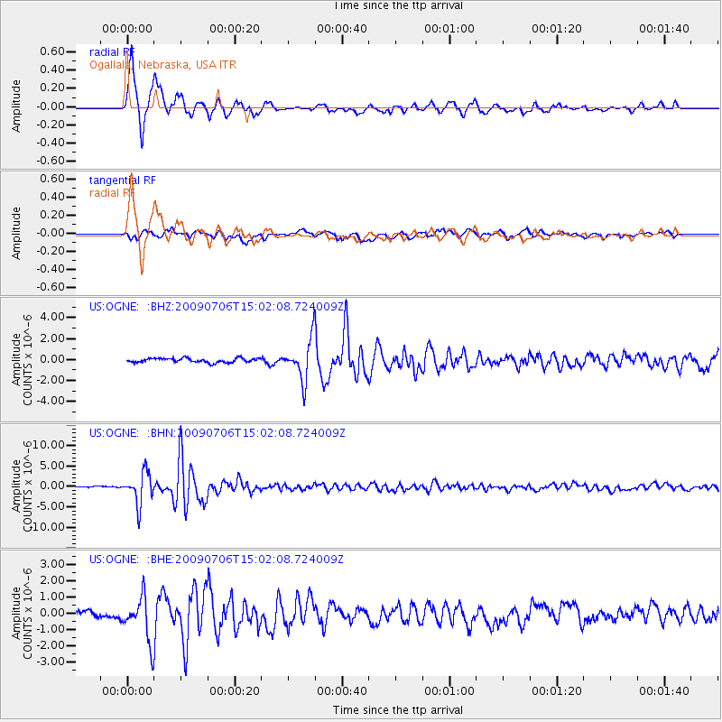
Earthquake location: Rat Islands, Aleutian Islands
Earthquake latitude/longitude: 50.4/177.0
Earthquake time(UTC): 2009/07/06 (187) 14:53:12 GMT
Earthquake Depth: 22 km
Earthquake Magnitude: 6.0 MB, 5.8 MS, 6.1 MW, 6.0 MW
Earthquake Catalog/Contributor: WHDF/NEIC
Network: US United States National Seismic Network
Station: OGNE Ogallala, Nebraska, USA
Lat/Lon: 40.95 N/102.03 W
Elevation: 0.0 m
Distance: 54.7 deg
Az: 66.447 deg
Baz: 309.297 deg
Ray Param: 0.06525508
Estimated Moho Depth: 29.5 km
Estimated Crust Vp/Vs: 2.10
Assumed Crust Vp: 6.483 km/s
Estimated Crust Vs: 3.091 km/s
Estimated Crust Poisson's Ratio: 0.35
Radial Match: 94.67087 %
Radial Bump: 400
Transverse Match: 73.09989 %
Transverse Bump: 400
SOD ConfigId: 2648
Insert Time: 2010-03-05 06:24:23.060 +0000
GWidth: 2.5
Max Bumps: 400
Tol: 0.001

Signal To Noise

ChannelStoNSTALTA
US:OGNE: :BHN:20090706T15:02:08.724009Z16.7108923.897494E-62.3323076E-7
US:OGNE: :BHE:20090706T15:02:08.724009Z4.8020131.3660625E-62.8447704E-7
US:OGNE: :BHZ:20090706T15:02:08.724009Z9.7408321.9412723E-61.9929224E-7
Arrivals
Ps5.2 SECOND
PpPs13 SECOND
PsPs/PpSs19 SECOND