You are here: Home > Network List > TA - USArray Transportable Network (new EarthScope stations) Stations List
> Station A21K Barrow, AK, USA > Earthquake Result Viewer
A21K Barrow, AK, USA - Earthquake Result Viewer
| Earthquake location: |
Central Italy |
| Earthquake latitude/longitude: |
42.7/13.2 |
| Earthquake time(UTC): |
2016/08/24 (237) 01:36:33 GMT |
| Earthquake Depth: |
10 km |
| Earthquake Magnitude: |
6.2 MWP |
| Earthquake Catalog/Contributor: |
NEIC PDE/NEIC COMCAT |
|
| Network: |
TA USArray Transportable Network (new EarthScope stations) |
| Station: |
A21K Barrow, AK, USA |
| Lat/Lon: |
71.32 N/156.62 W |
| Elevation: |
577 m |
|
| Distance: |
66.0 deg |
| Az: |
356.417 deg |
| Baz: |
8.22 deg |
| Ray Param: |
0.057878617 |
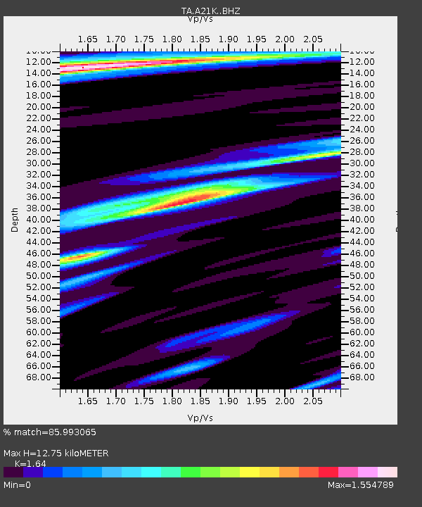
| Estimated Moho Depth: |
12.75 km |
| Estimated Crust Vp/Vs: |
1.64 |
| Assumed Crust Vp: |
6.048 km/s |
| Estimated Crust Vs: |
3.688 km/s |
| Estimated Crust Poisson's Ratio: |
0.20 |
|
| Radial Match: |
85.993065 % |
| Radial Bump: |
388 |
| Transverse Match: |
73.31408 % |
| Transverse Bump: |
400 |
| SOD ConfigId: |
11737051 |
| Insert Time: |
2019-04-25 08:31:06.394 +0000 |
| GWidth: |
2.5 |
| Max Bumps: |
400 |
| Tol: |
0.001 |
|
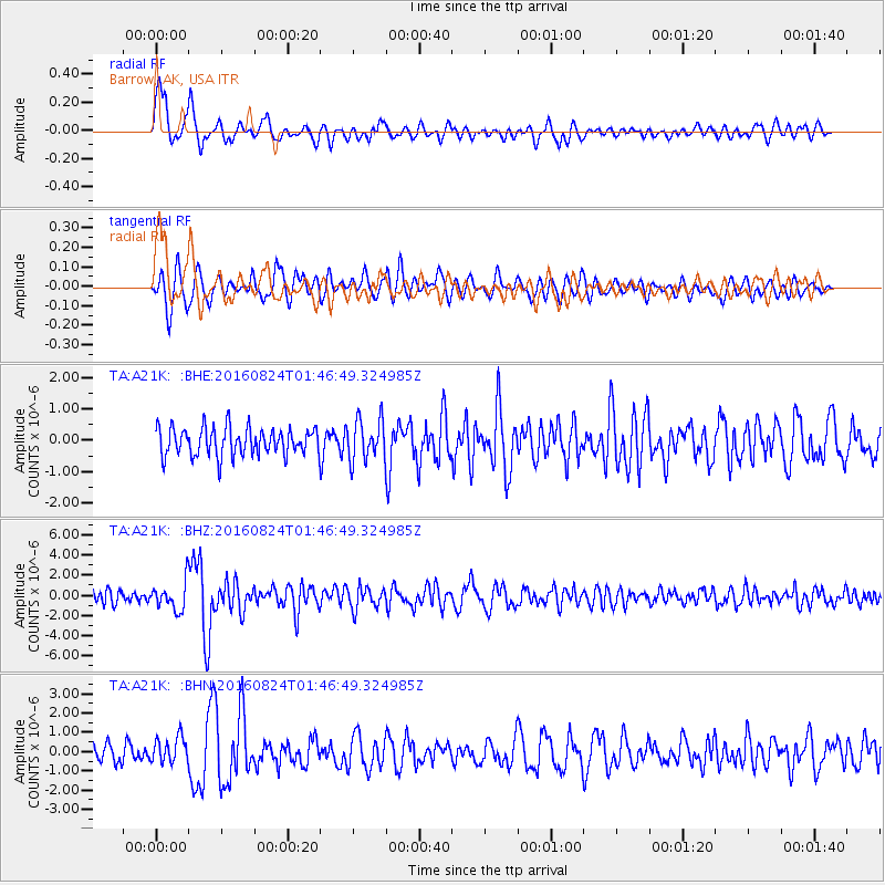
Signal To Noise
| Channel | StoN | STA | LTA |
| TA:A21K: :BHZ:20160824T01:46:49.324985Z | 1.9624687 | 1.3882288E-6 | 7.07389E-7 |
| TA:A21K: :BHN:20160824T01:46:49.324985Z | 1.4409629 | 6.7199267E-7 | 4.6634972E-7 |
| TA:A21K: :BHE:20160824T01:46:49.324985Z | 1.4764556 | 6.4818903E-7 | 4.3901696E-7 |
| Arrivals |
| Ps | 1.4 SECOND |
| PpPs | 5.4 SECOND |
| PsPs/PpSs | 6.8 SECOND |


