You are here: Home > Network List > TA - USArray Transportable Network (new EarthScope stations) Stations List
> Station I03D Drain, OR, USA > Earthquake Result Viewer
I03D Drain, OR, USA - Earthquake Result Viewer
| Earthquake location: |
Central Italy |
| Earthquake latitude/longitude: |
42.7/13.2 |
| Earthquake time(UTC): |
2016/08/24 (237) 01:36:33 GMT |
| Earthquake Depth: |
10 km |
| Earthquake Magnitude: |
6.2 MWP |
| Earthquake Catalog/Contributor: |
NEIC PDE/NEIC COMCAT |
|
| Network: |
TA USArray Transportable Network (new EarthScope stations) |
| Station: |
I03D Drain, OR, USA |
| Lat/Lon: |
43.70 N/123.35 W |
| Elevation: |
140 m |
|
| Distance: |
85.6 deg |
| Az: |
329.961 deg |
| Baz: |
30.575 deg |
| Ray Param: |
0.044675842 |
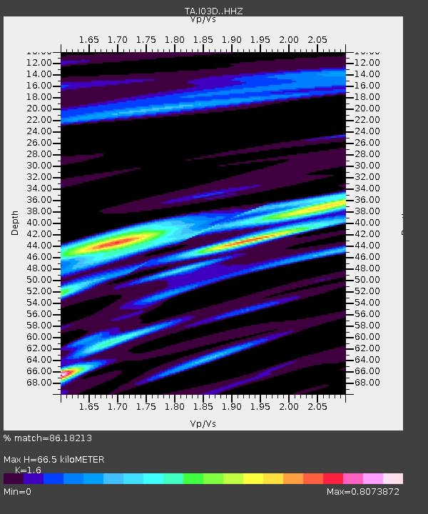
| Estimated Moho Depth: |
66.5 km |
| Estimated Crust Vp/Vs: |
1.60 |
| Assumed Crust Vp: |
6.522 km/s |
| Estimated Crust Vs: |
4.076 km/s |
| Estimated Crust Poisson's Ratio: |
0.18 |
|
| Radial Match: |
86.18213 % |
| Radial Bump: |
400 |
| Transverse Match: |
73.3097 % |
| Transverse Bump: |
400 |
| SOD ConfigId: |
11737051 |
| Insert Time: |
2019-04-25 08:31:34.643 +0000 |
| GWidth: |
2.5 |
| Max Bumps: |
400 |
| Tol: |
0.001 |
|
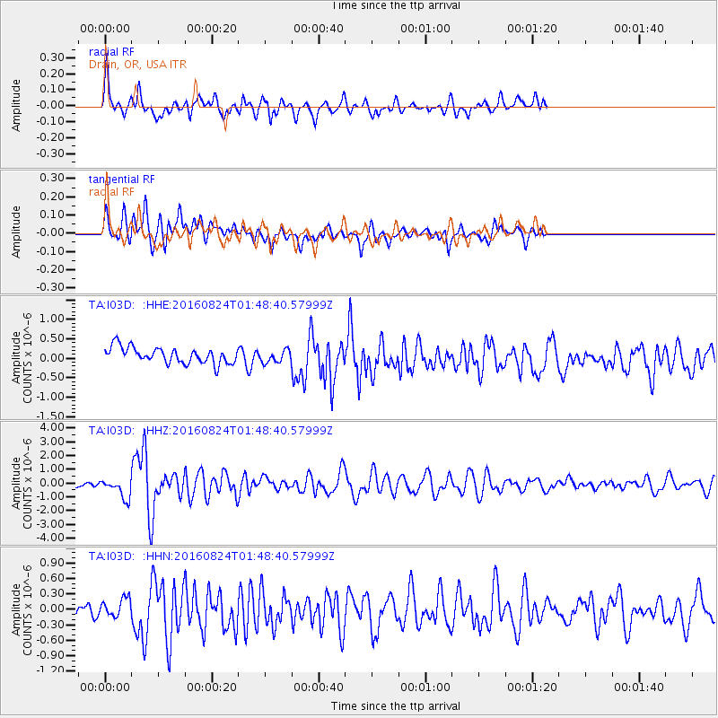
Signal To Noise
| Channel | StoN | STA | LTA |
| TA:I03D: :HHZ:20160824T01:48:40.57999Z | 4.44586 | 7.122971E-7 | 1.6021582E-7 |
| TA:I03D: :HHN:20160824T01:48:40.57999Z | 1.0748748 | 1.9275319E-7 | 1.793262E-7 |
| TA:I03D: :HHE:20160824T01:48:40.57999Z | 0.79341453 | 1.6173902E-7 | 2.0385184E-7 |
| Arrivals |
| Ps | 6.3 SECOND |
| PpPs | 26 SECOND |
| PsPs/PpSs | 32 SECOND |


