You are here: Home > Network List > TA - USArray Transportable Network (new EarthScope stations) Stations List
> Station P52A Corning, OH, USA > Earthquake Result Viewer
P52A Corning, OH, USA - Earthquake Result Viewer
| Earthquake location: |
Central Italy |
| Earthquake latitude/longitude: |
42.7/13.2 |
| Earthquake time(UTC): |
2016/08/24 (237) 01:36:33 GMT |
| Earthquake Depth: |
10 km |
| Earthquake Magnitude: |
6.2 MWP |
| Earthquake Catalog/Contributor: |
NEIC PDE/NEIC COMCAT |
|
| Network: |
TA USArray Transportable Network (new EarthScope stations) |
| Station: |
P52A Corning, OH, USA |
| Lat/Lon: |
39.63 N/82.13 W |
| Elevation: |
293 m |
|
| Distance: |
67.9 deg |
| Az: |
303.89 deg |
| Baz: |
52.396 deg |
| Ray Param: |
0.056678127 |
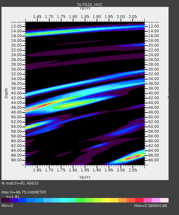
| Estimated Moho Depth: |
46.75 km |
| Estimated Crust Vp/Vs: |
1.61 |
| Assumed Crust Vp: |
6.232 km/s |
| Estimated Crust Vs: |
3.871 km/s |
| Estimated Crust Poisson's Ratio: |
0.19 |
|
| Radial Match: |
91.48633 % |
| Radial Bump: |
272 |
| Transverse Match: |
56.250698 % |
| Transverse Bump: |
360 |
| SOD ConfigId: |
11737051 |
| Insert Time: |
2019-04-25 08:32:26.266 +0000 |
| GWidth: |
2.5 |
| Max Bumps: |
400 |
| Tol: |
0.001 |
|

Signal To Noise
| Channel | StoN | STA | LTA |
| TA:P52A: :HHZ:20160824T01:47:00.999973Z | 14.465195 | 1.0062548E-6 | 6.956387E-8 |
| TA:P52A: :HHN:20160824T01:47:00.999973Z | 1.7371606 | 2.4709374E-7 | 1.4224003E-7 |
| TA:P52A: :HHE:20160824T01:47:00.999973Z | 1.5540038 | 2.1670252E-7 | 1.3944786E-7 |
| Arrivals |
| Ps | 4.8 SECOND |
| PpPs | 19 SECOND |
| PsPs/PpSs | 24 SECOND |


