You are here: Home > Network List > TA - USArray Transportable Network (new EarthScope stations) Stations List
> Station R11A Troy Canyon, Currant, NV, USA > Earthquake Result Viewer
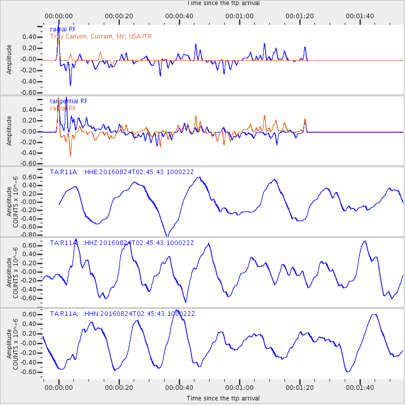
R11A Troy Canyon, Currant, NV, USA - Earthquake Result Viewer
*The percent match for this event was below the threshold and hence no stack was calculated.
| Earthquake location: |
Central Italy |
| Earthquake latitude/longitude: |
42.8/13.1 |
| Earthquake time(UTC): |
2016/08/24 (237) 02:33:30 GMT |
| Earthquake Depth: |
10 km |
| Earthquake Magnitude: |
5.5 MB |
| Earthquake Catalog/Contributor: |
NEIC PDE/NEIC COMCAT |
|
| Network: |
TA USArray Transportable Network (new EarthScope stations) |
| Station: |
R11A Troy Canyon, Currant, NV, USA |
| Lat/Lon: |
38.35 N/115.59 W |
| Elevation: |
1756 m |
|
| Distance: |
86.8 deg |
| Az: |
322.083 deg |
| Baz: |
35.102 deg |
| Ray Param: |
$rayparam |
*The percent match for this event was below the threshold and hence was not used in the summary stack. |
|
| Radial Match: |
82.173 % |
| Radial Bump: |
400 |
| Transverse Match: |
70.464966 % |
| Transverse Bump: |
400 |
| SOD ConfigId: |
11737051 |
| Insert Time: |
2019-04-25 08:43:13.298 +0000 |
| GWidth: |
2.5 |
| Max Bumps: |
400 |
| Tol: |
0.001 |
|
Signal To Noise
| Channel | StoN | STA | LTA |
| TA:R11A: :HHZ:20160824T02:45:43.100022Z | 1.0525191 | 1.612501E-7 | 1.5320397E-7 |
| TA:R11A: :HHN:20160824T02:45:43.100022Z | 1.707853 | 5.212046E-7 | 3.0518117E-7 |
| TA:R11A: :HHE:20160824T02:45:43.100022Z | 0.8820614 | 2.9029172E-7 | 3.2910603E-7 |
| Arrivals |
| Ps | |
| PpPs | |
| PsPs/PpSs | |


