You are here: Home > Network List > GS - US Geological Survey Networks Stations List
> Station DEC12 Decatur Surface Seismic Site, Decatur, IL, USA > Earthquake Result Viewer
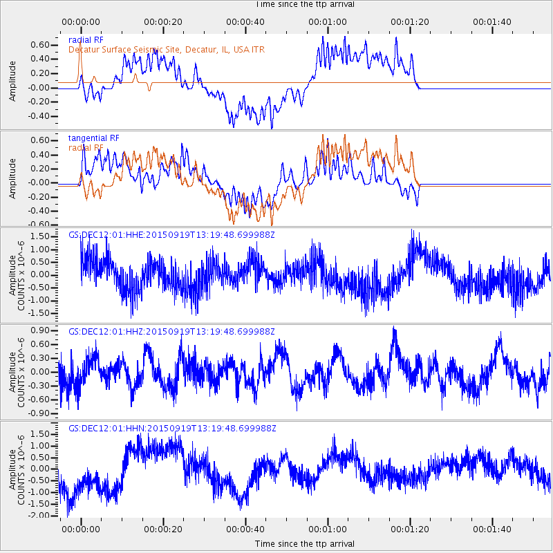
DEC12 Decatur Surface Seismic Site, Decatur, IL, USA - Earthquake Result Viewer
*The percent match for this event was below the threshold and hence no stack was calculated.
| Earthquake location: |
Off Coast Of Central Chile |
| Earthquake latitude/longitude: |
-30.6/-72.2 |
| Earthquake time(UTC): |
2015/09/19 (262) 13:08:57 GMT |
| Earthquake Depth: |
14 km |
| Earthquake Magnitude: |
5.6 MB |
| Earthquake Catalog/Contributor: |
NEIC PDE/NEIC ALERT |
|
| Network: |
GS US Geological Survey Networks |
| Station: |
DEC12 Decatur Surface Seismic Site, Decatur, IL, USA |
| Lat/Lon: |
39.91 N/88.91 W |
| Elevation: |
208 m |
|
| Distance: |
71.8 deg |
| Az: |
346.515 deg |
| Baz: |
164.842 deg |
| Ray Param: |
$rayparam |
*The percent match for this event was below the threshold and hence was not used in the summary stack. |
|
| Radial Match: |
60.36798 % |
| Radial Bump: |
359 |
| Transverse Match: |
49.564777 % |
| Transverse Bump: |
307 |
| SOD ConfigId: |
1156111 |
| Insert Time: |
2015-10-03 13:30:23.013 +0000 |
| GWidth: |
2.5 |
| Max Bumps: |
400 |
| Tol: |
0.001 |
|
Signal To Noise
| Channel | StoN | STA | LTA |
| GS:DEC12:01:HHZ:20150919T13:19:48.699988Z | 1.0447155 | 3.068769E-7 | 2.9374206E-7 |
| GS:DEC12:01:HHN:20150919T13:19:48.699988Z | 1.6293632 | 1.0200413E-6 | 6.260368E-7 |
| GS:DEC12:01:HHE:20150919T13:19:48.699988Z | 0.87295496 | 4.977677E-7 | 5.702101E-7 |
| Arrivals |
| Ps | |
| PpPs | |
| PsPs/PpSs | |


