You are here: Home > Network List > AK - Alaska Regional Network Stations List
> Station BMR Bremner River > Earthquake Result Viewer
BMR Bremner River - Earthquake Result Viewer
| Earthquake location: |
Myanmar |
| Earthquake latitude/longitude: |
20.9/94.6 |
| Earthquake time(UTC): |
2016/08/24 (237) 10:34:55 GMT |
| Earthquake Depth: |
84 km |
| Earthquake Magnitude: |
6.8 MO |
| Earthquake Catalog/Contributor: |
NEIC PDE/NEIC ALERT |
|
| Network: |
AK Alaska Regional Network |
| Station: |
BMR Bremner River |
| Lat/Lon: |
60.97 N/144.60 W |
| Elevation: |
842 m |
|
| Distance: |
85.6 deg |
| Az: |
24.843 deg |
| Baz: |
306.369 deg |
| Ray Param: |
0.04445865 |
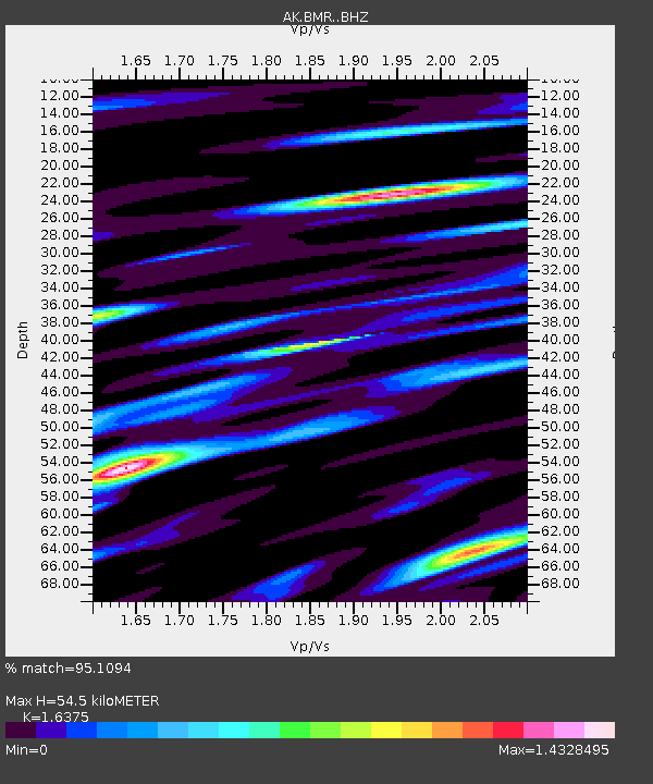
| Estimated Moho Depth: |
54.5 km |
| Estimated Crust Vp/Vs: |
1.64 |
| Assumed Crust Vp: |
6.566 km/s |
| Estimated Crust Vs: |
4.01 km/s |
| Estimated Crust Poisson's Ratio: |
0.20 |
|
| Radial Match: |
95.1094 % |
| Radial Bump: |
400 |
| Transverse Match: |
87.888954 % |
| Transverse Bump: |
400 |
| SOD ConfigId: |
11737051 |
| Insert Time: |
2019-04-25 08:46:12.845 +0000 |
| GWidth: |
2.5 |
| Max Bumps: |
400 |
| Tol: |
0.001 |
|

Signal To Noise
| Channel | StoN | STA | LTA |
| AK:BMR: :BHZ:20160824T10:46:52.927979Z | 110.03124 | 1.3649256E-5 | 1.2404892E-7 |
| AK:BMR: :BHN:20160824T10:46:52.927979Z | 39.040394 | 5.9650247E-6 | 1.5279109E-7 |
| AK:BMR: :BHE:20160824T10:46:52.927979Z | 68.874146 | 9.629618E-6 | 1.3981472E-7 |
| Arrivals |
| Ps | 5.4 SECOND |
| PpPs | 21 SECOND |
| PsPs/PpSs | 27 SECOND |


