You are here: Home > Network List > US - United States National Seismic Network Stations List
> Station TPNV Topopah Spring, Nevada, USA > Earthquake Result Viewer
TPNV Topopah Spring, Nevada, USA - Earthquake Result Viewer

| Earthquake location: |
Chile-Bolivia Border Region |
| Earthquake latitude/longitude: |
-20.0/-68.8 |
| Earthquake time(UTC): |
2005/06/21 (172) 05:11:18 GMT |
| Earthquake Depth: |
105 km |
| Earthquake Magnitude: |
5.4 MB, 5.6 MW, 5.5 MW |
| Earthquake Catalog/Contributor: |
WHDF/NEIC |
|
| Network: |
US United States National Seismic Network |
| Station: |
TPNV Topopah Spring, Nevada, USA |
| Lat/Lon: |
36.95 N/116.25 W |
| Elevation: |
1600 m |
|
| Distance: |
72.2 deg |
| Az: |
321.693 deg |
| Baz: |
133.302 deg |
| Ray Param: |
0.053582694 |
| Estimated Moho Depth: |
67.25 km |
| Estimated Crust Vp/Vs: |
2.04 |
| Assumed Crust Vp: |
6.279 km/s |
| Estimated Crust Vs: |
3.074 km/s |
| Estimated Crust Poisson's Ratio: |
0.34 |
|
| Radial Match: |
92.83877 % |
| Radial Bump: |
136 |
| Transverse Match: |
95.3406 % |
| Transverse Bump: |
134 |
| SOD ConfigId: |
110165 |
| Insert Time: |
2010-03-05 06:25:56.801 +0000 |
| GWidth: |
2.5 |
| Max Bumps: |
400 |
| Tol: |
0.001 |
|
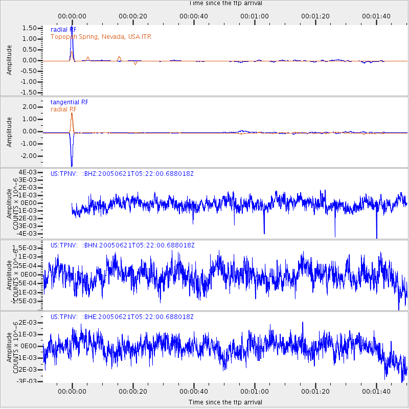
Signal To Noise
| Channel | StoN | STA | LTA |
| US:TPNV: :BHN:20050621T05:22:00.688018Z | 1.0164585 | 4.6028445E-10 | 4.528315E-10 |
| US:TPNV: :BHE:20050621T05:22:00.688018Z | 1.293271 | 8.1657814E-10 | 6.314053E-10 |
| US:TPNV: :BHZ:20050621T05:22:00.688018Z | 0.8462905 | 5.507298E-10 | 6.507574E-10 |
| Arrivals |
| Ps | 11 SECOND |
| PpPs | 32 SECOND |
| PsPs/PpSs | 43 SECOND |


