You are here: Home > Network List > US - United States National Seismic Network Stations List
> Station TPNV Topopah Spring, Nevada, USA > Earthquake Result Viewer
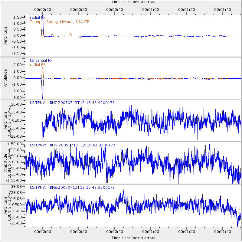
TPNV Topopah Spring, Nevada, USA - Earthquake Result Viewer

| Earthquake location: |
Near Coast Of Peru |
| Earthquake latitude/longitude: |
-17.8/-70.1 |
| Earthquake time(UTC): |
2005/07/13 (194) 12:06:13 GMT |
| Earthquake Depth: |
80 km |
| Earthquake Magnitude: |
5.6 MB, 5.9 MW, 5.8 MW |
| Earthquake Catalog/Contributor: |
WHDF/NEIC |
|
| Network: |
US United States National Seismic Network |
| Station: |
TPNV Topopah Spring, Nevada, USA |
| Lat/Lon: |
36.95 N/116.25 W |
| Elevation: |
1600 m |
|
| Distance: |
69.7 deg |
| Az: |
321.994 deg |
| Baz: |
132.938 deg |
| Ray Param: |
0.05525931 |
| Estimated Moho Depth: |
38.75 km |
| Estimated Crust Vp/Vs: |
2.10 |
| Assumed Crust Vp: |
6.279 km/s |
| Estimated Crust Vs: |
2.993 km/s |
| Estimated Crust Poisson's Ratio: |
0.35 |
|
| Radial Match: |
91.19653 % |
| Radial Bump: |
184 |
| Transverse Match: |
91.96808 % |
| Transverse Bump: |
175 |
| SOD ConfigId: |
2669 |
| Insert Time: |
2010-03-05 06:25:58.975 +0000 |
| GWidth: |
2.5 |
| Max Bumps: |
400 |
| Tol: |
0.001 |
|
Signal To Noise
| Channel | StoN | STA | LTA |
| US:TPNV: :BHN:20050713T12:16:43.920017Z | 1.3934299 | 6.763717E-10 | 4.854006E-10 |
| US:TPNV: :BHE:20050713T12:16:43.920017Z | 0.8483728 | 4.983908E-10 | 5.8746674E-10 |
| US:TPNV: :BHZ:20050713T12:16:43.920017Z | 1.1341103 | 8.199272E-10 | 7.229695E-10 |
| Arrivals |
| Ps | 7.0 SECOND |
| PpPs | 19 SECOND |
| PsPs/PpSs | 26 SECOND |


