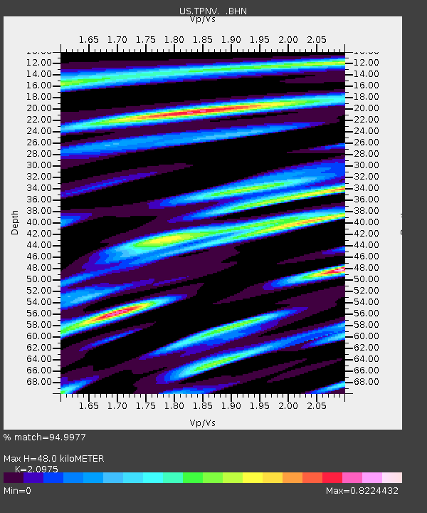
TPNV Topopah Spring, Nevada, USA - Earthquake Result Viewer
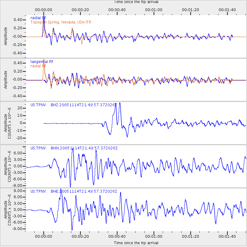
Earthquake location: Off East Coast Of Honshu, Japan
Earthquake latitude/longitude: 38.1/144.9
Earthquake time(UTC): 2005/11/14 (318) 21:38:51 GMT
Earthquake Depth: 11 km
Earthquake Magnitude: 6.7 MB, 6.8 MS, 7.0 MW, 6.9 MW
Earthquake Catalog/Contributor: WHDF/NEIC
Network: US United States National Seismic Network
Station: TPNV Topopah Spring, Nevada, USA
Lat/Lon: 36.95 N/116.25 W
Elevation: 1600 m
Distance: 74.3 deg
Az: 55.308 deg
Baz: 305.937 deg
Ray Param: 0.0524225
Estimated Moho Depth: 48.0 km
Estimated Crust Vp/Vs: 2.10
Assumed Crust Vp: 6.279 km/s
Estimated Crust Vs: 2.993 km/s
Estimated Crust Poisson's Ratio: 0.35
Radial Match: 94.9977 %
Radial Bump: 400
Transverse Match: 91.73765 %
Transverse Bump: 400
SOD ConfigId: 2448
Insert Time: 2010-03-05 06:26:12.645 +0000
GWidth: 2.5
Max Bumps: 400
Tol: 0.001

Signal To Noise

ChannelStoNSTALTA
US:TPNV: :BHN:20051114T21:49:57.372026Z3.79088544.7039924E-71.2408691E-7
US:TPNV: :BHE:20051114T21:49:57.372026Z2.29011375.678087E-72.4793906E-7
US:TPNV: :BHZ:20051114T21:49:57.372026Z14.5109262.2717827E-61.565567E-7
Arrivals
Ps8.6 SECOND
PpPs23 SECOND
PsPs/PpSs32 SECOND