You are here: Home > Network List > US - United States National Seismic Network Stations List
> Station TPNV Topopah Spring, Nevada, USA > Earthquake Result Viewer
TPNV Topopah Spring, Nevada, USA - Earthquake Result Viewer
| Earthquake location: |
North Of Honduras |
| Earthquake latitude/longitude: |
17.2/-84.8 |
| Earthquake time(UTC): |
2008/03/27 (087) 09:42:57 GMT |
| Earthquake Depth: |
10 km |
| Earthquake Magnitude: |
5.6 MW, 5.1 MS, 5.4 MB, 5.6 MW |
| Earthquake Catalog/Contributor: |
WHDF/NEIC |
|
| Network: |
US United States National Seismic Network |
| Station: |
TPNV Topopah Spring, Nevada, USA |
| Lat/Lon: |
36.95 N/116.25 W |
| Elevation: |
1600 m |
|
| Distance: |
34.0 deg |
| Az: |
311.634 deg |
| Baz: |
116.904 deg |
| Ray Param: |
0.077965155 |
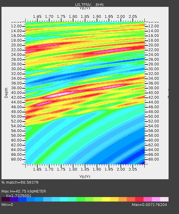
| Estimated Moho Depth: |
40.75 km |
| Estimated Crust Vp/Vs: |
1.73 |
| Assumed Crust Vp: |
6.279 km/s |
| Estimated Crust Vs: |
3.624 km/s |
| Estimated Crust Poisson's Ratio: |
0.25 |
|
| Radial Match: |
98.59379 % |
| Radial Bump: |
74 |
| Transverse Match: |
98.7603 % |
| Transverse Bump: |
60 |
| SOD ConfigId: |
2564 |
| Insert Time: |
2010-03-05 06:26:16.625 +0000 |
| GWidth: |
2.5 |
| Max Bumps: |
400 |
| Tol: |
0.001 |
|

Signal To Noise
| Channel | StoN | STA | LTA |
| US:TPNV: :BHN:20080327T09:49:10.372014Z | 0.9263324 | 3.5678302E-10 | 3.851566E-10 |
| US:TPNV: :BHE:20080327T09:49:10.372014Z | 1.0038422 | 5.7908317E-10 | 5.768667E-10 |
| US:TPNV: :BHZ:20080327T09:49:10.372014Z | 1.1512352 | 5.3302446E-10 | 4.6300222E-10 |
| Arrivals |
| Ps | 5.1 SECOND |
| PpPs | 16 SECOND |
| PsPs/PpSs | 22 SECOND |


