You are here: Home > Network List > US - United States National Seismic Network Stations List
> Station TPNV Topopah Spring, Nevada, USA > Earthquake Result Viewer
TPNV Topopah Spring, Nevada, USA - Earthquake Result Viewer
| Earthquake location: |
Chile-Bolivia Border Region |
| Earthquake latitude/longitude: |
-20.0/-69.0 |
| Earthquake time(UTC): |
2008/03/24 (084) 20:39:07 GMT |
| Earthquake Depth: |
120 km |
| Earthquake Magnitude: |
5.7 MB, 6.2 MW, 6.1 MW |
| Earthquake Catalog/Contributor: |
WHDF/NEIC |
|
| Network: |
US United States National Seismic Network |
| Station: |
TPNV Topopah Spring, Nevada, USA |
| Lat/Lon: |
36.95 N/116.25 W |
| Elevation: |
1600 m |
|
| Distance: |
72.1 deg |
| Az: |
321.795 deg |
| Baz: |
133.461 deg |
| Ray Param: |
0.053568646 |
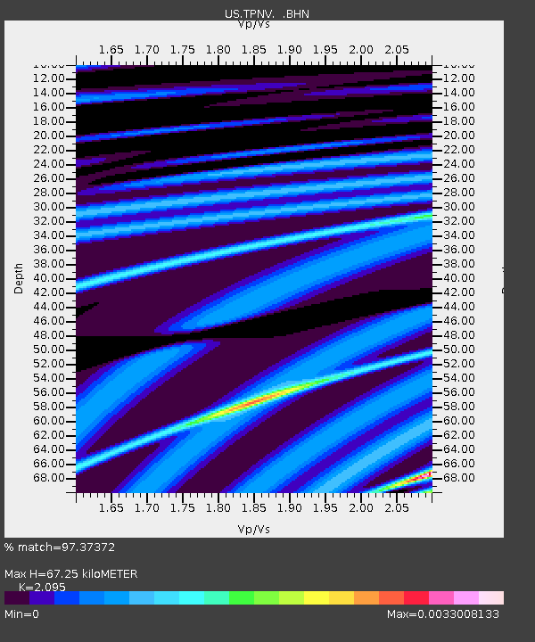
| Estimated Moho Depth: |
67.25 km |
| Estimated Crust Vp/Vs: |
2.10 |
| Assumed Crust Vp: |
6.279 km/s |
| Estimated Crust Vs: |
2.997 km/s |
| Estimated Crust Poisson's Ratio: |
0.35 |
|
| Radial Match: |
97.37372 % |
| Radial Bump: |
71 |
| Transverse Match: |
98.44894 % |
| Transverse Bump: |
78 |
| SOD ConfigId: |
2564 |
| Insert Time: |
2010-03-05 06:26:17.979 +0000 |
| GWidth: |
2.5 |
| Max Bumps: |
400 |
| Tol: |
0.001 |
|

Signal To Noise
| Channel | StoN | STA | LTA |
| US:TPNV: :BHN:20080324T20:49:48.148005Z | 1.0709966 | 4.2106627E-10 | 3.9315368E-10 |
| US:TPNV: :BHE:20080324T20:49:48.148005Z | 0.95342785 | 5.2131466E-10 | 5.4677934E-10 |
| US:TPNV: :BHZ:20080324T20:49:48.148005Z | 1.4873499 | 7.2691053E-10 | 4.8872867E-10 |
| Arrivals |
| Ps | 12 SECOND |
| PpPs | 32 SECOND |
| PsPs/PpSs | 44 SECOND |


