You are here: Home > Network List > AU - Australian Seismological Centre Stations List
> Station XMIS Christmas Island Grants Well > Earthquake Result Viewer
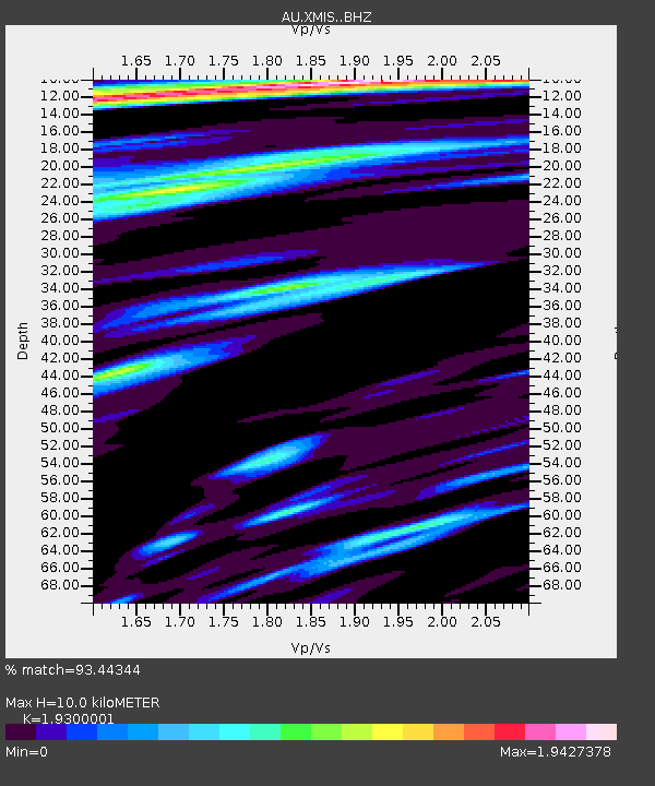
XMIS Christmas Island Grants Well - Earthquake Result Viewer
| Earthquake location: |
Myanmar |
| Earthquake latitude/longitude: |
20.9/94.6 |
| Earthquake time(UTC): |
2016/08/24 (237) 10:34:55 GMT |
| Earthquake Depth: |
84 km |
| Earthquake Magnitude: |
6.8 MO |
| Earthquake Catalog/Contributor: |
NEIC PDE/NEIC ALERT |
|
| Network: |
AU Australian Seismological Centre |
| Station: |
XMIS Christmas Island Grants Well |
| Lat/Lon: |
10.48 S/105.65 E |
| Elevation: |
210 m |
|
| Distance: |
33.0 deg |
| Az: |
159.733 deg |
| Baz: |
340.777 deg |
| Ray Param: |
0.0781609 |
| Estimated Moho Depth: |
10.0 km |
| Estimated Crust Vp/Vs: |
1.93 |
| Assumed Crust Vp: |
4.157 km/s |
| Estimated Crust Vs: |
2.154 km/s |
| Estimated Crust Poisson's Ratio: |
0.32 |
|
| Radial Match: |
93.44344 % |
| Radial Bump: |
400 |
| Transverse Match: |
79.28065 % |
| Transverse Bump: |
400 |
| SOD ConfigId: |
11737051 |
| Insert Time: |
2019-04-25 08:47:51.635 +0000 |
| GWidth: |
2.5 |
| Max Bumps: |
400 |
| Tol: |
0.001 |
|

Signal To Noise
| Channel | StoN | STA | LTA |
| AU:XMIS: :BHZ:20160824T10:40:52.019012Z | 11.939672 | 9.2389655E-6 | 7.7380395E-7 |
| AU:XMIS: :BHN:20160824T10:40:52.019012Z | 5.140759 | 5.243911E-6 | 1.0200655E-6 |
| AU:XMIS: :BHE:20160824T10:40:52.019012Z | 2.173492 | 1.7002036E-6 | 7.822452E-7 |
| Arrivals |
| Ps | 2.3 SECOND |
| PpPs | 6.9 SECOND |
| PsPs/PpSs | 9.2 SECOND |


