You are here: Home > Network List > US - United States National Seismic Network Stations List
> Station TPNV Topopah Spring, Nevada, USA > Earthquake Result Viewer
TPNV Topopah Spring, Nevada, USA - Earthquake Result Viewer
| Earthquake location: |
South Of Panama |
| Earthquake latitude/longitude: |
6.9/-82.4 |
| Earthquake time(UTC): |
2008/01/24 (024) 04:12:13 GMT |
| Earthquake Depth: |
10 km |
| Earthquake Magnitude: |
5.8 MW, 5.3 MS, 5.3 MB, 5.8 MW |
| Earthquake Catalog/Contributor: |
WHDF/NEIC |
|
| Network: |
US United States National Seismic Network |
| Station: |
TPNV Topopah Spring, Nevada, USA |
| Lat/Lon: |
36.95 N/116.25 W |
| Elevation: |
1600 m |
|
| Distance: |
42.9 deg |
| Az: |
319.042 deg |
| Baz: |
125.676 deg |
| Ray Param: |
0.0728796 |
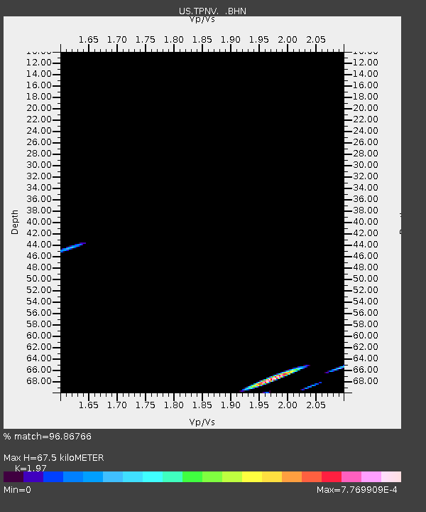
| Estimated Moho Depth: |
67.5 km |
| Estimated Crust Vp/Vs: |
1.97 |
| Assumed Crust Vp: |
6.279 km/s |
| Estimated Crust Vs: |
3.187 km/s |
| Estimated Crust Poisson's Ratio: |
0.33 |
|
| Radial Match: |
96.86766 % |
| Radial Bump: |
89 |
| Transverse Match: |
98.18033 % |
| Transverse Bump: |
76 |
| SOD ConfigId: |
2564 |
| Insert Time: |
2010-03-05 06:26:25.542 +0000 |
| GWidth: |
2.5 |
| Max Bumps: |
400 |
| Tol: |
0.001 |
|
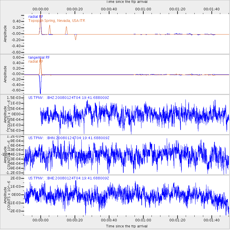
Signal To Noise
| Channel | StoN | STA | LTA |
| US:TPNV: :BHN:20080124T04:19:41.688009Z | 1.0230272 | 3.7711015E-10 | 3.6862183E-10 |
| US:TPNV: :BHE:20080124T04:19:41.688009Z | 1.1526977 | 6.2596506E-10 | 5.4304355E-10 |
| US:TPNV: :BHZ:20080124T04:19:41.688009Z | 1.3895001 | 5.746428E-10 | 4.1356077E-10 |
| Arrivals |
| Ps | 11 SECOND |
| PpPs | 30 SECOND |
| PsPs/PpSs | 41 SECOND |


